IMAGES TAKEN NEAR TO
Hillhouse Drive, BILLERICAY, CM12 0AZ
Introduction
This page details the photographs taken nearby to Hillhouse Drive, CM12 0AZ by members of the Geograph project.
The Geograph project started in 2005 with the aim of publishing, organising and preserving representative images for every square kilometre of Great Britain, Ireland and the Isle of Man.

There are currently over 7.5m images from over14,400 individuals and you can help contribute to the project by visiting https://www.geograph.org.uk
Image Map (Loading...)


Getting Data...Please wait
Leaflet Map data © OpenStreetMap
Images are licensed for reuse under creativecommons.org/licenses/by-sa/2.0
Notes
- Clicking on the map will re-center to the selected point.
- The higher the marker number, the further away the image location is from the centre of the postcode.
Image Listing (8 Images Found)
Images are licensed for reuse under creativecommons.org/licenses/by-sa/2.0
Image
Details
Distance
1
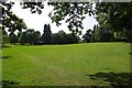
Lake Meadows Park
A green space in the middle of Billericay
Image: © Glyn Baker
Taken: 1 Sep 2013
0.17 miles
2
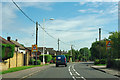
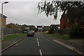
Stock Road, Billericay
The school ahead is the Mayflower High School, round the corner on the right.
Image: © Robin Webster
Taken: 22 Jul 2012
0.18 miles
4
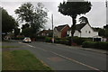
Stock Road, Billericay by St John's School
The school is behind the blue railings. Those at the bus stop are probably waiting for the 11:21 route 100 bus towards Chelmsford, evidently running some minutes late.
Image: © Robin Webster
Taken: 22 Jul 2012
0.21 miles
6

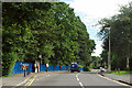
Poetry in the park
Tree stump in Lake Meadows Park, Billericay
Image: © John Webber
Taken: 19 Sep 2010
0.22 miles
7
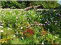
Lake Meadows
Flower meadow at the lakeside.
Image: © Ian Paterson
Taken: 8 Sep 2014
0.23 miles
8
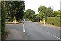
Norsey Road
This shows the junction of Headley Road, on the left, with Norsey Road, Billericay.
Image: © Trevor Harris
Taken: 4 Aug 2008
0.25 miles