IMAGES TAKEN NEAR TO
New Street, CHELMSFORD, CM1 1TA
Introduction
This page details the photographs taken nearby to New Street, CM1 1TA by members of the Geograph project.
The Geograph project started in 2005 with the aim of publishing, organising and preserving representative images for every square kilometre of Great Britain, Ireland and the Isle of Man.

There are currently over 7.5m images from over14,400 individuals and you can help contribute to the project by visiting https://www.geograph.org.uk
Image Map (Loading...)


Getting Data...Please wait
Leaflet Map data © OpenStreetMap
Images are licensed for reuse under creativecommons.org/licenses/by-sa/2.0
Notes
- Clicking on the map will re-center to the selected point.
- The higher the marker number, the further away the image location is from the centre of the postcode.
Image Listing (28 Images Found)
Images are licensed for reuse under creativecommons.org/licenses/by-sa/2.0
Image
Details
Distance
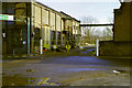
1
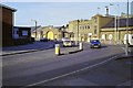
RHP buildings , New Street/Rectory Lane, 1990
Taken in January 1990 after closure of the works the previous year, and before any demolition.
Image: © Robin Webster
Taken: Unknown
0.04 miles
2
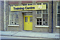
Training Centre, RHP bearing works, 1990
A view not long after the works closed for good just before Christmas 1989.
Image: © Robin Webster
Taken: Unknown
0.04 miles
3
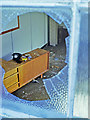
The office is closed, 1990
Looking through a broken window of the RHP bearing works, which had closed for good three or four weeks earlier.
Image: © Robin Webster
Taken: Unknown
0.04 miles
4
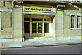
Office entrance, RHP bearings, 1990
A view shortly after the works closed for good just before Christmas 1989.
Image: © Robin Webster
Taken: Unknown
0.05 miles
5
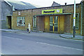
Personnel Department, RHP bearing works, 1990
A view not long after the works closed for good just before Christmas 1989.
Image: © Robin Webster
Taken: Unknown
0.05 miles
6
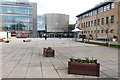
The Lord Ashcroft Building, part of the Anglia Ruskin University, Chelmsford
Image: © Derek Voller
Taken: 3 Mar 2016
0.05 miles
7
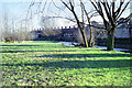
RHP works from across Chelmer, 1990
The RHP works closed in 1989. This view is from January 1990 before any demolition. The Chelmer looks an impressive river here, but it was never commercially navigable this far up.
Image: © Robin Webster
Taken: Unknown
0.07 miles
8
River Chelmer and RHP works, 1990
The works had closed for good two or three weeks earlier.
Image: © Robin Webster
Taken: Unknown
0.08 miles
9
Gate, RHP works
A view after the bearing works closed. The works was to either side of the foreground road, and once a railway line crossed here between the two sites.
Image: © Robin Webster
Taken: Unknown
0.09 miles
10
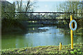
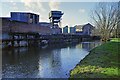
Bridge over River Chelmer, 1990
In the foreground is the junction between the bypass for Bishopshall Mill, coming in from the right, and the river downstream of the former mill, straight ahead. The bridge was believed to be a former pipe bridge between the parts of the RHP bearing works to either side of the river. The works had just closed for good at the time of this view, but it is believed that the small part to the right had been given over to other occupants earlier.
Image: © Robin Webster
Taken: Unknown
0.10 miles