IMAGES TAKEN NEAR TO
Bellmead, CHELMSFORD, CM1 1LE
Introduction
This page details the photographs taken nearby to Bellmead, CM1 1LE by members of the Geograph project.
The Geograph project started in 2005 with the aim of publishing, organising and preserving representative images for every square kilometre of Great Britain, Ireland and the Isle of Man.

There are currently over 7.5m images from over14,400 individuals and you can help contribute to the project by visiting https://www.geograph.org.uk
Image Map
Images are licensed for reuse under creativecommons.org/licenses/by-sa/2.0
Notes
- Clicking on the map will re-center to the selected point.
- The higher the marker number, the further away the image location is from the centre of the postcode.
Image Listing (279 Images Found)
Images are licensed for reuse under creativecommons.org/licenses/by-sa/2.0
Image
Details
Distance
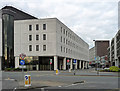
1
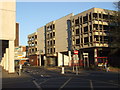
Chelmsford Market
This building in the centre of Chelmsford is an indoor market and multi-storey car park. It also houses a small bus station, in the corner nearest to the camera (behind the "no entry" sign).
Image: © Malc McDonald
Taken: 20 Apr 2013
0.04 miles
2
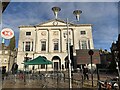
Shire Hall, Chelmsford on Remembrance Day 2018
The Shire Hall is Grade II* listed, see https://historicengland.org.uk/listing/the-list/list-entry/1141328
On this date it was empty, having ceased to be used as a judicial facility in 2012.
Image: © Jonathan Hutchins
Taken: 11 Nov 2018
0.05 miles
3
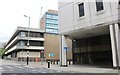
Office blocks on Victoria Road South, Chelmsford
Seax House is the one on the left which houses Essex's coroners service.
Image: © David Howard
Taken: 25 Aug 2024
0.05 miles
4
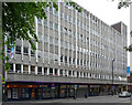
Threadneedle House, Chelmsford
On Market Road. Shops and offices dating from the 1960s/1970s. Quite long, with vertical emphasis provided by projecting concrete ribs. As ever with blocks of this vintage, office space is available.
Image: © Stephen Richards
Taken: 11 May 2011
0.06 miles
5
Library, Chelmsford
On Market Road and part of a larger civic block. I think it's built of reconstituted Portland stone, and dates from the 1980s.
Image: © Stephen Richards
Taken: 11 May 2011
0.06 miles
6
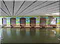
Bridge mural
Here the A1060 runs over the River Can at Chelmsford.
Image: © Julian P Guffogg
Taken: 15 Mar 2014
0.07 miles
7
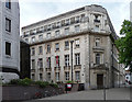
County Hall, Chelmsford (1)
County Hall is split between several sites in the town. This is the second phase, dating from 1929-38 by J. Stuart. Of Portland stone, and looking rather French, Pevsner's verdict was that it was "not a success". Grade II listed.
Image: © Stephen Richards
Taken: 11 May 2011
0.08 miles
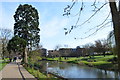
9
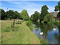
Chelmsford: Bell Meadow
Gardens each side of the River Can. Two of the floodlights at the Essex County Cricket Ground show above the trees on the left.
Image: © John Sutton
Taken: 23 Jun 2018
0.09 miles
10
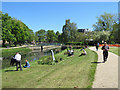
Chelmsford: lunch by the river
The gardens on this side of the River Can are Sky Blue Pasture. The footbridge to Bell Meadow, on the left bank, is new.
Image: © John Sutton
Taken: 14 May 2019
0.09 miles