IMAGES TAKEN NEAR TO
Bury Farm Lane, BILLERICAY, CM11 2XG
Introduction
This page details the photographs taken nearby to Bury Farm Lane, CM11 2XG by members of the Geograph project.
The Geograph project started in 2005 with the aim of publishing, organising and preserving representative images for every square kilometre of Great Britain, Ireland and the Isle of Man.

There are currently over 7.5m images from over14,400 individuals and you can help contribute to the project by visiting https://www.geograph.org.uk
Image Map (Loading...)


Getting Data...Please wait
Leaflet Map data © OpenStreetMap
Images are licensed for reuse under creativecommons.org/licenses/by-sa/2.0
Notes
- Clicking on the map will re-center to the selected point.
- The higher the marker number, the further away the image location is from the centre of the postcode.
Image Listing (3 Images Found)
Images are licensed for reuse under creativecommons.org/licenses/by-sa/2.0
Image
Details
Distance
1
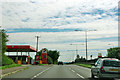
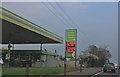
A127 - Total fuel station near Crays Hill
Unleaded petrol 132.9 and diesel 137.9 p/litre.
Image: © Robin Webster
Taken: 22 Jul 2012
0.24 miles
2
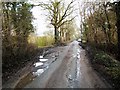
Oak Road
This is Oak Road south of Crays Hill it is a single-track road with passing places, one of them can be seen on the right. To the left of the picture by the fence is the start of a footpath to Crays Hill. The picture was taken looking west.
Image: © Glyn Baker
Taken: 18 Feb 2006
0.24 miles