IMAGES TAKEN NEAR TO
Coxes Farm Road, BILLERICAY, CM11 2UB
Introduction
This page details the photographs taken nearby to Coxes Farm Road, CM11 2UB by members of the Geograph project.
The Geograph project started in 2005 with the aim of publishing, organising and preserving representative images for every square kilometre of Great Britain, Ireland and the Isle of Man.

There are currently over 7.5m images from over14,400 individuals and you can help contribute to the project by visiting https://www.geograph.org.uk
Image Map
Images are licensed for reuse under creativecommons.org/licenses/by-sa/2.0
Notes
- Clicking on the map will re-center to the selected point.
- The higher the marker number, the further away the image location is from the centre of the postcode.
Image Listing (4 Images Found)
Images are licensed for reuse under creativecommons.org/licenses/by-sa/2.0
Image
Details
Distance
2
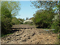
Muddy narrow field
It seems more churned up than ploughed, although a small tractor may be glimpsed parked in the middle.
Image: © Robin Webster
Taken: 2 May 2013
0.20 miles
3
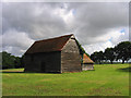
Traditional Essex Weatherboard Barn, near Billericay
This barn is located near Brown's Farm in Coxes Farm Road
Image: © John Winfield
Taken: 16 Sep 2005
0.20 miles
4
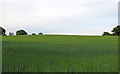
Arable Land near Oak Hill Farm, South Green
Image: © Roger Jones
Taken: 25 May 2019
0.21 miles