IMAGES TAKEN NEAR TO
Trinity Road, BILLERICAY, CM11 2RT
Introduction
This page details the photographs taken nearby to Trinity Road, CM11 2RT by members of the Geograph project.
The Geograph project started in 2005 with the aim of publishing, organising and preserving representative images for every square kilometre of Great Britain, Ireland and the Isle of Man.

There are currently over 7.5m images from over14,400 individuals and you can help contribute to the project by visiting https://www.geograph.org.uk
Image Map
Images are licensed for reuse under creativecommons.org/licenses/by-sa/2.0
Notes
- Clicking on the map will re-center to the selected point.
- The higher the marker number, the further away the image location is from the centre of the postcode.
Image Listing (4 Images Found)
Images are licensed for reuse under creativecommons.org/licenses/by-sa/2.0
Image
Details
Distance
1
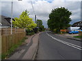
Church Street, Great Burstead
Looking east.
Image: © JThomas
Taken: 11 May 2019
0.15 miles
2
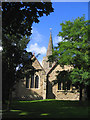
Great Burstead Parish Church, Essex
A medieval church, mainly built in the 14th/15th centuries. It dates back to Norman times and the nave window dates back to this time. The tower & steeple are 14th century and constructed of Kentish Ragstone.
Image: © John Winfield
Taken: 16 Sep 2005
0.17 miles
4
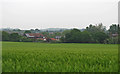
Looking over Wheat Field to Grange Farm, Great Burstead
Image: © Roger Jones
Taken: 19 May 2019
0.25 miles