IMAGES TAKEN NEAR TO
Salesbury Drive, BILLERICAY, CM11 2JH
Introduction
This page details the photographs taken nearby to Salesbury Drive, CM11 2JH by members of the Geograph project.
The Geograph project started in 2005 with the aim of publishing, organising and preserving representative images for every square kilometre of Great Britain, Ireland and the Isle of Man.

There are currently over 7.5m images from over14,400 individuals and you can help contribute to the project by visiting https://www.geograph.org.uk
Image Map (Loading...)


Getting Data...Please wait
Leaflet Map data © OpenStreetMap
Images are licensed for reuse under creativecommons.org/licenses/by-sa/2.0
Notes
- Clicking on the map will re-center to the selected point.
- The higher the marker number, the further away the image location is from the centre of the postcode.
Image Listing (7 Images Found)
Images are licensed for reuse under creativecommons.org/licenses/by-sa/2.0
Image
Details
Distance
1
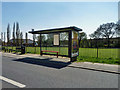
Bus shelter and playing field
In the Sunnymede area of Billericay.
Image: © Robin Webster
Taken: 2 May 2013
0.06 miles
2
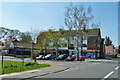
Shops, Sunnymead, Billericay
At the corner of Morris Avenue and Green Way.
Image: © Robin Webster
Taken: 2 May 2013
0.09 miles
3
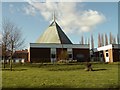
St. John's church at Sunnymede
Built in 1963.
Image: © Robert Edwards
Taken: 6 Feb 2008
0.13 miles
4
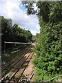
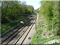
Railway Lines, Billericay, Essex
Liverpool Street-Southend line - looking west towards Billericay Station.
Image: © John Winfield
Taken: 16 Sep 2005
0.21 miles
5
Railway towards Billericay and London
The line from Southend Victoria, first electrified at 1500 V D.C., then converted to 6.25 kV later 25 kV A.C.
Image: © Robin Webster
Taken: 2 May 2013
0.21 miles
6
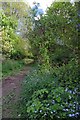
Footpath & Forget-me-nots
This is the path that runs from near Image to Outwood Farm Road
Image: © Glyn Baker
Taken: 3 May 2015
0.21 miles
7
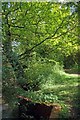
Footpath & Stream
This is the path that runs from Sunnymede to Outwood Farm Road
Image: © Glyn Baker
Taken: 3 May 2015
0.22 miles