IMAGES TAKEN NEAR TO
Belvedere Close, BILLERICAY, CM11 2ET
Introduction
This page details the photographs taken nearby to Belvedere Close, CM11 2ET by members of the Geograph project.
The Geograph project started in 2005 with the aim of publishing, organising and preserving representative images for every square kilometre of Great Britain, Ireland and the Isle of Man.

There are currently over 7.5m images from over14,400 individuals and you can help contribute to the project by visiting https://www.geograph.org.uk
Image Map (Loading...)


Getting Data...Please wait
Leaflet Map data © OpenStreetMap
Images are licensed for reuse under creativecommons.org/licenses/by-sa/2.0
Notes
- Clicking on the map will re-center to the selected point.
- The higher the marker number, the further away the image location is from the centre of the postcode.
Image Listing (7 Images Found)
Images are licensed for reuse under creativecommons.org/licenses/by-sa/2.0
Image
Details
Distance
1
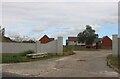
The Belvedere, Billericay
A new estate with an unfinished drive.
Image: © David Howard
Taken: 25 Aug 2024
0.05 miles
2
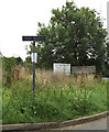
Oak Road sign
On Oak Road at the junction with Harding's Elms Road
Image: © Geographer
Taken: 5 Sep 2015
0.07 miles
3
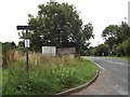
Harding's Elms Road, Crays Hill
At the junction with Oak Road
Image: © Geographer
Taken: 5 Sep 2015
0.08 miles
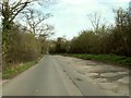
4
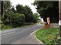
Harding's Elms Road, Crays Hill
At the junction with Oak Road
Image: © Geographer
Taken: 5 Sep 2015
0.08 miles
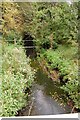
7
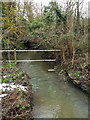
River Crouch
This stream that passes under Wash Road joins the River Crouch north of the Southend Road. This used to be a Ford before the stream was bridged. If you look on the right side of the stream it is possible to see part of the old road.
See other photo of this streamImage
Image: © terry joyce
Taken: 15 Jan 2010
0.20 miles