IMAGES TAKEN NEAR TO
West Croft, BILLERICAY, CM11 2BP
Introduction
This page details the photographs taken nearby to West Croft, CM11 2BP by members of the Geograph project.
The Geograph project started in 2005 with the aim of publishing, organising and preserving representative images for every square kilometre of Great Britain, Ireland and the Isle of Man.

There are currently over 7.5m images from over14,400 individuals and you can help contribute to the project by visiting https://www.geograph.org.uk
Image Map (Loading...)


Getting Data...Please wait
Leaflet Map data © OpenStreetMap
Images are licensed for reuse under creativecommons.org/licenses/by-sa/2.0
Notes
- Clicking on the map will re-center to the selected point.
- The higher the marker number, the further away the image location is from the centre of the postcode.
Image Listing (4 Images Found)
Images are licensed for reuse under creativecommons.org/licenses/by-sa/2.0
Image
Details
Distance
1
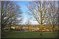
Mill Meadows
This is Mill Meadows Nature Reserve looking back towards Billericay see http://www.millmeadows.org.uk/ for more info.
Image: © Glyn Baker
Taken: 2 Jan 2010
0.11 miles
2
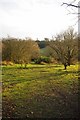
Mill Meadows Reserve
This is Mill Meadows Nature Reserve see http://www.millmeadows.org.uk/ for more info.
Image: © Glyn Baker
Taken: 2 Jan 2010
0.12 miles
3
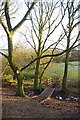
Mill Meadows Span
This footbridge is in Image Nature Reserve see http://www.millmeadows.org.uk/ for more info.
Image: © Glyn Baker
Taken: 2 Jan 2010
0.18 miles
4
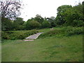
Footbridge in Mill Meadows
Typical landscape in this wonderful park.
Image: © Ian Paterson
Taken: 12 May 2011
0.25 miles