IMAGES TAKEN NEAR TO
Church Road, BILLERICAY, CM11 1RH
Introduction
This page details the photographs taken nearby to Church Road, CM11 1RH by members of the Geograph project.
The Geograph project started in 2005 with the aim of publishing, organising and preserving representative images for every square kilometre of Great Britain, Ireland and the Isle of Man.

There are currently over 7.5m images from over14,400 individuals and you can help contribute to the project by visiting https://www.geograph.org.uk
Image Map (Loading...)


Getting Data...Please wait
Leaflet Map data © OpenStreetMap
Images are licensed for reuse under creativecommons.org/licenses/by-sa/2.0
Notes
- Clicking on the map will re-center to the selected point.
- The higher the marker number, the further away the image location is from the centre of the postcode.
Image Listing (4 Images Found)
Images are licensed for reuse under creativecommons.org/licenses/by-sa/2.0
Image
Details
Distance
1
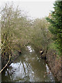
River Crouch
This is the River Crouch just before it flows under Church Road, Ramsden Bellhouse.
Image: © terry joyce
Taken: 28 Dec 2009
0.19 miles
2

Old Bridge Marker on Church Road Bridge, Ramsden Bellhouse parish
Bridge Marker by the UC road, in parish of Ramsden Bellhouse (Basildon District), Church Road Bridge, River Crouch, built into brick parapet, West side of road.
Inscription reads:-
B U D C
1939
Surveyed
Milestone Society National ID: EX_RBELL01br
Image: © Milestone Society
Taken: Unknown
0.20 miles
3
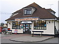
Ramsden Bellhouse Village Store
General Store and Post Office
Image: © Angela Tuff
Taken: 23 Jan 2006
0.20 miles
4
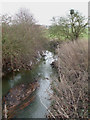
River Crouch
This is the River Crouch just after it passes under Church Road, Ramsden Bellhouse.
Image: © terry joyce
Taken: 28 Dec 2009
0.22 miles