IMAGES TAKEN NEAR TO
School Road, BILLERICAY, CM11 1QU
Introduction
This page details the photographs taken nearby to School Road, CM11 1QU by members of the Geograph project.
The Geograph project started in 2005 with the aim of publishing, organising and preserving representative images for every square kilometre of Great Britain, Ireland and the Isle of Man.

There are currently over 7.5m images from over14,400 individuals and you can help contribute to the project by visiting https://www.geograph.org.uk
Image Map (Loading...)


Getting Data...Please wait
Leaflet Map data © OpenStreetMap
Images are licensed for reuse under creativecommons.org/licenses/by-sa/2.0
Notes
- Clicking on the map will re-center to the selected point.
- The higher the marker number, the further away the image location is from the centre of the postcode.
Image Listing (5 Images Found)
Images are licensed for reuse under creativecommons.org/licenses/by-sa/2.0
Image
Details
Distance
2
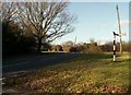
Part of Castledon Road in Downham
This view is just a short distance from Downham church.
Image: © Robert Edwards
Taken: 6 Feb 2008
0.14 miles
3
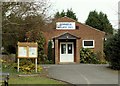
Bus stops on School Road, Downham
The stops are named 'Village Hall', which is set back just off to the left.
Image: © Robin Webster
Taken: 25 Mar 2018
0.16 miles
4
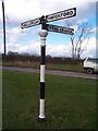
Direction Sign ? Signpost
Formerly located on a grass triangle at the junction of Castledon Road and Grange Lane in South Hanningfield parish. 3 arms and lost finial. See also https://www.geograph.org.uk/photo/681989. This interesting fingerpost probably dates to a few years either side of 1900. It is certainly a unique survivor in Essex. It was taller and about three feet of the height was lost from the bottom of the pillar in the late 1990s. Broken off at ground level and presumed stolen in 2012.
Milestone Society National ID: EX_TQ7395
Image: © John V Nicholls
Taken: Unknown
0.19 miles