IMAGES TAKEN NEAR TO
De Beauvoir Chase, BILLERICAY, CM11 1PR
Introduction
This page details the photographs taken nearby to De Beauvoir Chase, CM11 1PR by members of the Geograph project.
The Geograph project started in 2005 with the aim of publishing, organising and preserving representative images for every square kilometre of Great Britain, Ireland and the Isle of Man.

There are currently over 7.5m images from over14,400 individuals and you can help contribute to the project by visiting https://www.geograph.org.uk
Image Map (Loading...)


Getting Data...Please wait
Leaflet Map data © OpenStreetMap
Images are licensed for reuse under creativecommons.org/licenses/by-sa/2.0
Notes
- Clicking on the map will re-center to the selected point.
- The higher the marker number, the further away the image location is from the centre of the postcode.
Image Listing (5 Images Found)
Images are licensed for reuse under creativecommons.org/licenses/by-sa/2.0
Image
Details
Distance
1
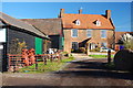
De Beauvoir House
An impressive old farmhouse. Taken from the bridleway which follows the old lane - De Beauvoir Chase.
Image: © Trevor Harris
Taken: 11 Nov 2012
0.00 miles
2
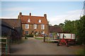
De Beauvoir House and Farm
Image: © Glyn Baker
Taken: 29 Jun 2013
0.01 miles
3
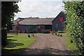
De Beauvoir Farm
Looking along the bridleway
Image: © Glyn Baker
Taken: 29 Jun 2013
0.02 miles
4
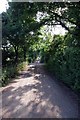
De Beauvoir Chase
Looking towards Church Road this section is marked on the map as a public footpath.
Image: © Glyn Baker
Taken: 29 Jun 2013
0.17 miles
5
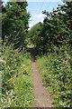
Bridleway to Downham Hall
This is the bridleway from Ramsden Bellhouse to Downham Hall (looking towards Downham Hall) at the point where it just dips across the grid line into the square.
Image: © Glyn Baker
Taken: 29 Jun 2013
0.21 miles