IMAGES TAKEN NEAR TO
Vera Road, BILLERICAY, CM11 1LJ
Introduction
This page details the photographs taken nearby to Vera Road, CM11 1LJ by members of the Geograph project.
The Geograph project started in 2005 with the aim of publishing, organising and preserving representative images for every square kilometre of Great Britain, Ireland and the Isle of Man.

There are currently over 7.5m images from over14,400 individuals and you can help contribute to the project by visiting https://www.geograph.org.uk
Image Map (Loading...)


Getting Data...Please wait
Leaflet Map data © OpenStreetMap
Images are licensed for reuse under creativecommons.org/licenses/by-sa/2.0
Notes
- Clicking on the map will re-center to the selected point.
- The higher the marker number, the further away the image location is from the centre of the postcode.
Image Listing (6 Images Found)
Images are licensed for reuse under creativecommons.org/licenses/by-sa/2.0
Image
Details
Distance
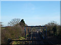
1
Castledown Railway Bridge
This bridge carries Castledown Road over the Shenfield to Southend Victoria railway line. The photo was taken looking northbound
Image: © Glyn Baker
Taken: 18 Feb 2006
0.08 miles
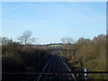
2
Castledon Road Railway Bridge
Taken from the bridge in Castledon Road,Wickford; this is the Southend Victoria to London Liverpool Street Line looking towards Wickford.
Image: © terry joyce
Taken: 16 Jan 2012
0.13 miles
3
View from the Bridge
Taken from the bridge in Castledon Road,Wickford; this is the Southend Victoria to London Liverpool Street Line looking towards Ramsden Bellhouse.
Image: © terry joyce
Taken: 16 Jan 2012
0.17 miles
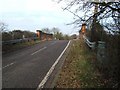
4
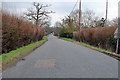
Castledon Road
Heading towards Wickford.
Image: © Robin Webster
Taken: 25 Mar 2018
0.18 miles