IMAGES TAKEN NEAR TO
Fernlea Place, BILLERICAY, CM11 1GG
Introduction
This page details the photographs taken nearby to Fernlea Place, CM11 1GG by members of the Geograph project.
The Geograph project started in 2005 with the aim of publishing, organising and preserving representative images for every square kilometre of Great Britain, Ireland and the Isle of Man.

There are currently over 7.5m images from over14,400 individuals and you can help contribute to the project by visiting https://www.geograph.org.uk
Image Map
Images are licensed for reuse under creativecommons.org/licenses/by-sa/2.0
Notes
- Clicking on the map will re-center to the selected point.
- The higher the marker number, the further away the image location is from the centre of the postcode.
Image Listing (8 Images Found)
Images are licensed for reuse under creativecommons.org/licenses/by-sa/2.0
Image
Details
Distance
1
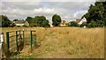
Path out of Norsey Woods
Across the meadow
Image: © Chris Morgan
Taken: 10 Aug 2015
0.04 miles
2
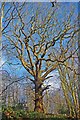
A Norsey Oak
This impressive oak in Norsey Wood has a girth of 4.5m and is still in its maiden form.
Image: © Glyn Baker
Taken: 2 Jan 2010
0.16 miles
3
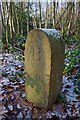
Boundary Marker
This old War Department boundary marker indicates Norsey Wood’s military past evidence of which can also be seen at Image
Image: © Glyn Baker
Taken: 2 Jan 2010
0.16 miles
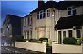
4
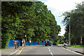
Stock Road, Billericay by St John's School
The school is behind the blue railings. Those at the bus stop are probably waiting for the 11:21 route 100 bus towards Chelmsford, evidently running some minutes late.
Image: © Robin Webster
Taken: 22 Jul 2012
0.18 miles
5
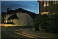
Stock Road at the junction of St Andrews Drive
Image: © David Howard
Taken: 3 Sep 2017
0.19 miles
6
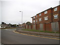
Stock Road, Billericay
At the junction of Cromwell Avenue
Image: © David Howard
Taken: 29 Oct 2023
0.22 miles
7
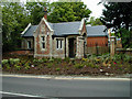
Gate House of old St. Andrews Hospital, Norsey Road, Billericay
Image: © John Webber
Taken: 30 Nov 2007
0.23 miles