IMAGES TAKEN NEAR TO
Jacksons Lane, BILLERICAY, CM11 1AH
Introduction
This page details the photographs taken nearby to Jacksons Lane, CM11 1AH by members of the Geograph project.
The Geograph project started in 2005 with the aim of publishing, organising and preserving representative images for every square kilometre of Great Britain, Ireland and the Isle of Man.

There are currently over 7.5m images from over14,400 individuals and you can help contribute to the project by visiting https://www.geograph.org.uk
Image Map (Loading...)


Getting Data...Please wait
Leaflet Map data © OpenStreetMap
Images are licensed for reuse under creativecommons.org/licenses/by-sa/2.0
Notes
- Clicking on the map will re-center to the selected point.
- The higher the marker number, the further away the image location is from the centre of the postcode.
Image Listing (8 Images Found)
Images are licensed for reuse under creativecommons.org/licenses/by-sa/2.0
Image
Details
Distance
1
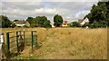
Path out of Norsey Woods
Across the meadow
Image: © Chris Morgan
Taken: 10 Aug 2015
0.07 miles
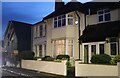
2
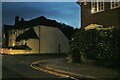
Stock Road at the junction of St Andrews Drive
Image: © David Howard
Taken: 3 Sep 2017
0.18 miles
3
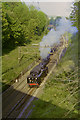
Steam at Billericay, 2002
76079 reverses back towards London in the cutting east of Billericay station after hauling the 'Cockney Coaster' in the down direction. It was preceded by the up special train hauled by 45407 (as 45157) and an electric train.
Image: © Robin Webster
Taken: 6 May 2002
0.19 miles
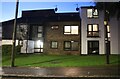
4
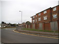
Stock Road, Billericay
At the junction of Cromwell Avenue
Image: © David Howard
Taken: 29 Oct 2023
0.19 miles
5
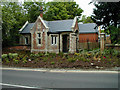
Gate House of old St. Andrews Hospital, Norsey Road, Billericay
Image: © John Webber
Taken: 30 Nov 2007
0.20 miles
8
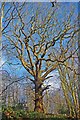
A Norsey Oak
This impressive oak in Norsey Wood has a girth of 4.5m and is still in its maiden form.
Image: © Glyn Baker
Taken: 2 Jan 2010
0.25 miles