IMAGES TAKEN NEAR TO
Springfield Industrial Estate, Springfield Road, BURNHAM-ON-CROUCH, CM0 8UA
Introduction
This page details the photographs taken nearby to Springfield Industrial Estate, Springfield Road, CM0 8UA by members of the Geograph project.
The Geograph project started in 2005 with the aim of publishing, organising and preserving representative images for every square kilometre of Great Britain, Ireland and the Isle of Man.

There are currently over 7.5m images from over14,400 individuals and you can help contribute to the project by visiting https://www.geograph.org.uk
Image Map
Images are licensed for reuse under creativecommons.org/licenses/by-sa/2.0
Notes
- Clicking on the map will re-center to the selected point.
- The higher the marker number, the further away the image location is from the centre of the postcode.
Image Listing (5 Images Found)
Images are licensed for reuse under creativecommons.org/licenses/by-sa/2.0
Image
Details
Distance
1
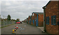
Industrial buildings in Foundry Lane, Burnham-on-Crouch
Situated between Foundry Lane and the railway line just west of Burnham-on-Crouch station.
Image: © David Kemp
Taken: 19 Mar 2023
0.15 miles
2

Burnham on Crouch Country Park
Burnham Country Park http://www.wildessex.net/sites/Burnham%20Country%20Park.htm consists of about 50 acres of coastal grassland on the western edge of the centre of town.
Image: © Glyn Baker
Taken: 21 May 2011
0.16 miles
3
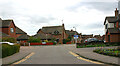
Junction of Fairway Drive & Hornet Way (left), Burnham-on-Crouch
Image: © David Kemp
Taken: 19 Mar 2023
0.16 miles
4
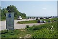
Country Park Car Park
This is one of the two car-parks for Burnham Country Park If you look hard the photographers 130,000 mile old jalopy is just to the left of the centre of the shot.
Image: © Glyn Baker
Taken: 21 May 2011
0.17 miles
5

Road to the marina
Looking along the road from the marina end.
Image: © Trevor Harris
Taken: 22 Sep 2012
0.23 miles