IMAGES TAKEN NEAR TO
Maple Way, BURNHAM-ON-CROUCH, CM0 8TR
Introduction
This page details the photographs taken nearby to Maple Way, CM0 8TR by members of the Geograph project.
The Geograph project started in 2005 with the aim of publishing, organising and preserving representative images for every square kilometre of Great Britain, Ireland and the Isle of Man.

There are currently over 7.5m images from over14,400 individuals and you can help contribute to the project by visiting https://www.geograph.org.uk
Image Map (Loading...)


Getting Data...Please wait
Leaflet Map data © OpenStreetMap
Images are licensed for reuse under creativecommons.org/licenses/by-sa/2.0
Notes
- Clicking on the map will re-center to the selected point.
- The higher the marker number, the further away the image location is from the centre of the postcode.
Image Listing (4 Images Found)
Images are licensed for reuse under creativecommons.org/licenses/by-sa/2.0
Image
Details
Distance
1
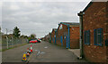
Industrial buildings in Foundry Lane, Burnham-on-Crouch
Situated between Foundry Lane and the railway line just west of Burnham-on-Crouch station.
Image: © David Kemp
Taken: 19 Mar 2023
0.18 miles
2
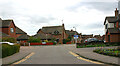
Junction of Fairway Drive & Hornet Way (left), Burnham-on-Crouch
Image: © David Kemp
Taken: 19 Mar 2023
0.21 miles
3
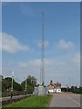
Railway wireless communications mast
Radio mast for wireless communications along the railway. Burnham-On-Crouch station building can be seen in the background.
see also Image]
Image: © Roger Jones
Taken: 20 May 2012
0.24 miles
4

Burnham-on-Crouch Station
View westward, towards Wickford; ex-Great Eastern, (Shenfield) - Wickford - Southminster line, electrified in 1986.
Image: © Ben Brooksbank
Taken: 9 Apr 1961
0.25 miles