IMAGES TAKEN NEAR TO
Tideways Row, Riverside Road, BURNHAM-ON-CROUCH, CM0 8TG
Introduction
This page details the photographs taken nearby to Tideways Row, Riverside Road, CM0 8TG by members of the Geograph project.
The Geograph project started in 2005 with the aim of publishing, organising and preserving representative images for every square kilometre of Great Britain, Ireland and the Isle of Man.

There are currently over 7.5m images from over14,400 individuals and you can help contribute to the project by visiting https://www.geograph.org.uk
Image Map
Images are licensed for reuse under creativecommons.org/licenses/by-sa/2.0
Notes
- Clicking on the map will re-center to the selected point.
- The higher the marker number, the further away the image location is from the centre of the postcode.
Image Listing (139 Images Found)
Images are licensed for reuse under creativecommons.org/licenses/by-sa/2.0
Image
Details
Distance
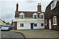
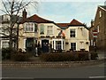
1
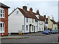
Houses on High Street, Burnham-on-Crouch
Grade II listed buildings.
Image: © Robin Webster
Taken: 25 Mar 2018
0.06 miles
2
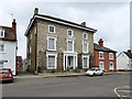
Large house, High Street, Burnham-on-Crouch
A mid 19th century grade II listed building.
Image: © Robin Webster
Taken: 25 Mar 2018
0.06 miles
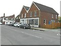
3
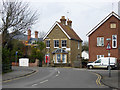
Corner house, Silver Road, Burnham-on-Crouch
The sign says 'Silver Road Caravan Park', which is reached down an alley (evidently just wide enough) just to the right of the house.
Image: © Robin Webster
Taken: 25 Mar 2018
0.06 miles
4
Victoria Inn in 1980
Corner of Silver Road and Belvedere Road where the Victoria Inn is located. Photograph taken here in Burnham-on-Crouch in 1980.
Image: © Clint Mann
Taken: Unknown
0.07 miles
5
Cottage, High Street, Burnham-on-Crouch
An 18th century grade II listed building.
Image: © Robin Webster
Taken: 25 Mar 2018
0.07 miles
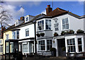
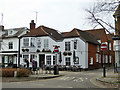
7
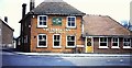
The Victoria, Burnham-on-Crouch
At the east end of the High Street.
Image: © Robin Webster
Taken: 25 Mar 2018
0.07 miles
8
87 High Street, Burnham-on-Crouch
Planning permission has been granted by Maldon District Council under application number 11/00380/FUL for the “change of use of part ground floor area from retail (A1) to Dental practice (D1). Demolition of attached single storey rear extension and addition of new bay window. Alterations to existing first floor living accommodation and extension into loft space”. Number 87 is on the right side of the building and appears to be empty.
Image: © John Baker
Taken: 3 Apr 2014
0.08 miles
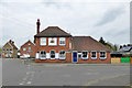
10
The Ship Inn, Burnham-on-Crouch
On the north side of the High Street.
Image: © Robin Webster
Taken: 25 Mar 2018
0.09 miles