IMAGES TAKEN NEAR TO
Heron Grove, CM0 8SX
Introduction
This page details the photographs taken nearby to Heron Grove, CM0 8SX by members of the Geograph project.
The Geograph project started in 2005 with the aim of publishing, organising and preserving representative images for every square kilometre of Great Britain, Ireland and the Isle of Man.

There are currently over 7.5m images from over14,400 individuals and you can help contribute to the project by visiting https://www.geograph.org.uk
Image Map (Loading...)


Getting Data...Please wait
Leaflet Map data © OpenStreetMap
Images are licensed for reuse under creativecommons.org/licenses/by-sa/2.0
Notes
- Clicking on the map will re-center to the selected point.
- The higher the marker number, the further away the image location is from the centre of the postcode.
Image Listing (15 Images Found)
Images are licensed for reuse under creativecommons.org/licenses/by-sa/2.0
Image
Details
Distance
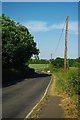
1
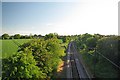
Towards Burnham on Crouch
This shot was taken from the Bridge on Marsh Rd see Image The railway would doubtless have been Beechinged in the 1960's if it had not been for the nuclear waste trains from Image The Dengie Peninsula is within viable commuting distance to London because of the survival of the railway.
Image: © Glyn Baker
Taken: 21 May 2011
0.10 miles
2
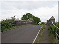
Marsh Road railway bridge
This is bridge 830: 43m, 60ch from Liverpool Street which carries Marsh Road over the Crouch Valley Line.
Image: © Roger Jones
Taken: 20 May 2012
0.11 miles
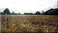
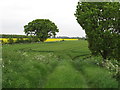
3
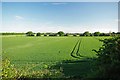
Marsh Road to Wick Road
Looking across arable fields to the east of Burnham on Crouch
Image: © Glyn Baker
Taken: 21 May 2011
0.11 miles
4
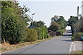
Marsh Road north of Burnham
Looking towards the bridge which carries the road over the railway line to Southminster.
Image: © Trevor Harris
Taken: 15 Sep 2016
0.11 miles
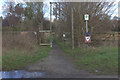
6
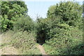
Footpath to Romans Farm
Here the path enters a patch of wood and scrub where it goes over a footbridge to proceed northwards.
Image: © Trevor Harris
Taken: 15 Sep 2016
0.14 miles
7
From public footpath north of Burnham
View from public footpath north of Burnham (between Marsh Road and Pannells Brook) looks across fence to Glebe field. Church of St Mary the Virgin visible in middle right of image.
Image: © Clint Mann
Taken: Unknown
0.14 miles
8
Burnham Water
This Anglian Water company facility stands near Romans Farm on a footpath that runs from Marsh Rd to Mill Rd in Burnham-on-Crouch
Image: © Glyn Baker
Taken: 15 Aug 2006
0.16 miles
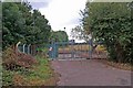
9
No Through Road
Marsh Road is nearly 5km long as far as East Wick where the right of way ends but once there in a car you just have to turn round and drive back.
Image: © Glyn Baker
Taken: 21 May 2011
0.16 miles
10
Entrance to arable field
On the outskirts of Burnham-On-Crouch, along Marsh Road.
Image: © Roger Jones
Taken: 20 May 2012
0.17 miles