IMAGES TAKEN NEAR TO
Mill Grange, Mill Road, BURNHAM-ON-CROUCH, CM0 8PD
Introduction
This page details the photographs taken nearby to Mill Grange, Mill Road, CM0 8PD by members of the Geograph project.
The Geograph project started in 2005 with the aim of publishing, organising and preserving representative images for every square kilometre of Great Britain, Ireland and the Isle of Man.

There are currently over 7.5m images from over14,400 individuals and you can help contribute to the project by visiting https://www.geograph.org.uk
Image Map
Images are licensed for reuse under creativecommons.org/licenses/by-sa/2.0
Notes
- Clicking on the map will re-center to the selected point.
- The higher the marker number, the further away the image location is from the centre of the postcode.
Image Listing (5 Images Found)
Images are licensed for reuse under creativecommons.org/licenses/by-sa/2.0
Image
Details
Distance
1

Looking over fields towards Romans Farm
Image: © Roger Jones
Taken: 22 Oct 2011
0.18 miles
2
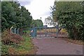
Burnham Water
This Anglian Water company facility stands near Romans Farm on a footpath that runs from Marsh Rd to Mill Rd in Burnham-on-Crouch
Image: © Glyn Baker
Taken: 15 Aug 2006
0.20 miles
3
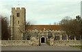
St. Mary; the parish church of Burnham-On-Crouch
For this area of Essex the church is of an unusual design whereby the dimensions of the chancel is the same as the nave with no real division and, because of that, it has a total of nine bays. It mainly dates from the 14th century and probably replaces an earlier Norman structure as the font is c.1200. It is a well cared for church and stands a good distance north of the original village that lies by the river Crouch.
Image: © Robert Edwards
Taken: 5 Mar 2008
0.23 miles
4
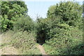
Footpath to Romans Farm
Here the path enters a patch of wood and scrub where it goes over a footbridge to proceed northwards.
Image: © Trevor Harris
Taken: 15 Sep 2016
0.24 miles
5
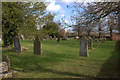
St Mary the Virgin churchyard, Burnham on Crouch
Image: © Robert Eva
Taken: 1 Feb 2018
0.25 miles