IMAGES TAKEN NEAR TO
King Edward Avenue, BURNHAM-ON-CROUCH, CM0 8PB
Introduction
This page details the photographs taken nearby to King Edward Avenue, CM0 8PB by members of the Geograph project.
The Geograph project started in 2005 with the aim of publishing, organising and preserving representative images for every square kilometre of Great Britain, Ireland and the Isle of Man.

There are currently over 7.5m images from over14,400 individuals and you can help contribute to the project by visiting https://www.geograph.org.uk
Image Map
Images are licensed for reuse under creativecommons.org/licenses/by-sa/2.0
Notes
- Clicking on the map will re-center to the selected point.
- The higher the marker number, the further away the image location is from the centre of the postcode.
Image Listing (16 Images Found)
Images are licensed for reuse under creativecommons.org/licenses/by-sa/2.0
Image
Details
Distance
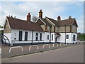
1
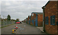
Industrial buildings in Foundry Lane, Burnham-on-Crouch
Situated between Foundry Lane and the railway line just west of Burnham-on-Crouch station.
Image: © David Kemp
Taken: 19 Mar 2023
0.19 miles
2
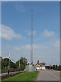
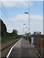
Railway wireless communications mast
Radio mast for wireless communications along the railway. Burnham-On-Crouch station building can be seen in the background.
see also Image]
Image: © Roger Jones
Taken: 20 May 2012
0.21 miles
3

Burnham-on-Crouch Station
View westward, towards Wickford; ex-Great Eastern, (Shenfield) - Wickford - Southminster line, electrified in 1986.
Image: © Ben Brooksbank
Taken: 9 Apr 1961
0.21 miles
4
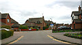
Junction of Fairway Drive & Hornet Way (left), Burnham-on-Crouch
Image: © David Kemp
Taken: 19 Mar 2023
0.22 miles
5
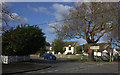
Maldon Road and Church Road junction, Burnham on Crouch
Image: © Robert Eva
Taken: 1 Feb 2018
0.23 miles
6
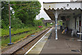
Platform and mast
A few from the west end of the platform at Burnham-On-Crouch station, showing the radio mast Image]
Image: © Roger Jones
Taken: 20 May 2012
0.23 miles
7
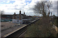
Burnham on Crouch Station
Unusually for a British branch line, the penultimate station before the terminus at Southminster serves a larger and more important place. As this view shows, Burnham's station was once more extensive than it is now - the passing loop and down platform having gone many years ago. Nevertheless, unlike several other stations on the line, Burnham retains a booking office, albeit only open for a few hours on weekday mornings, and even has a small coffee shop (note the stacked tables and chairs - this was not really a morning conducive to sitting out of doors). Defying a threat of closure, which had lingered around for many years, the line was electrified in 1986.
Image: © Stephen McKay
Taken: 13 Jun 2015
0.24 miles
8
Burnham on Crouch station
Looking westwards from Church Road bridge
Image: © Robert Eva
Taken: 1 Feb 2018
0.24 miles
9
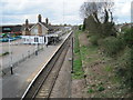
Burnham-on-Crouch railway station, Essex
Opened in 1889 by the Great Eastern Railway on its line from Wickford to Southminster.
View west towards Althorne and Wickford. The remains of the second platform can be seen on the right. The building was renovated a few years later.
Image: © Nigel Thompson
Taken: 27 Apr 2013
0.24 miles
10
Burnham on Crouch railway station building
Sadly all the windows now look boarded up on this old Great Eastern Railway station building.
Image: © Roger Jones
Taken: 20 May 2012
0.25 miles