IMAGES TAKEN NEAR TO
Marshes, BURNHAM-ON-CROUCH, CM0 8NQ
Introduction
This page details the photographs taken nearby to Marshes, CM0 8NQ by members of the Geograph project.
The Geograph project started in 2005 with the aim of publishing, organising and preserving representative images for every square kilometre of Great Britain, Ireland and the Isle of Man.

There are currently over 7.5m images from over14,400 individuals and you can help contribute to the project by visiting https://www.geograph.org.uk
Image Map
Images are licensed for reuse under creativecommons.org/licenses/by-sa/2.0
Notes
- Clicking on the map will re-center to the selected point.
- The higher the marker number, the further away the image location is from the centre of the postcode.
Image Listing (5 Images Found)
Images are licensed for reuse under creativecommons.org/licenses/by-sa/2.0
Image
Details
Distance
1
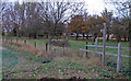
Footpath signpost near Deal Hall
You can follow the footpath over the muddy field, where in November it was very poorly defined, or a slightly longer distance on the (private) metalled road.
To the right of the signpost there is also the footpath marker post.
Image: © Roger Jones
Taken: 6 Nov 2011
0.05 miles
2
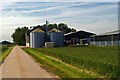
Deal Hall Farm
These grain dryers are on Deal Hall Farm the road is a public footpath from Montsale to sea wall via Holliwell Farm. Only access is from Southminster. Private land Strutt & Parker Farms Ltd. No public right of way to Burnham.
Image: © Glyn Baker
Taken: 4 Jun 2006
0.15 miles
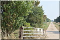
3
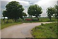
Road Closed?
The gate is used to block a private road that branches off from the footpath/private road near Deal Hall.
Image: © Glyn Baker
Taken: 4 Jun 2006
0.17 miles
4
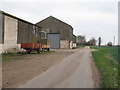
Farm buildings near Coney Hall
Taken from public footpath on private road.
Image: © Roger Jones
Taken: 6 Nov 2011
0.18 miles
5
Farm track from Deal Hall
The private track runs east through what a notice on the gate describes as a conservation area.
Image: © Trevor Harris
Taken: 15 Sep 2016
0.23 miles