IMAGES TAKEN NEAR TO
Arcadia Road, BURNHAM-ON-CROUCH, CM0 8EF
Introduction
This page details the photographs taken nearby to Arcadia Road, CM0 8EF by members of the Geograph project.
The Geograph project started in 2005 with the aim of publishing, organising and preserving representative images for every square kilometre of Great Britain, Ireland and the Isle of Man.

There are currently over 7.5m images from over14,400 individuals and you can help contribute to the project by visiting https://www.geograph.org.uk
Image Map
Images are licensed for reuse under creativecommons.org/licenses/by-sa/2.0
Notes
- Clicking on the map will re-center to the selected point.
- The higher the marker number, the further away the image location is from the centre of the postcode.
Image Listing (6 Images Found)
Images are licensed for reuse under creativecommons.org/licenses/by-sa/2.0
Image
Details
Distance
2
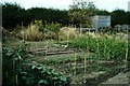
Boundary hedge at Allotment Gardens in Burnham
The hedge depicted represents the boundary between the allotments and fields south of Marsh Road
Image: © Clint Mann
Taken: 23 Jul 2006
0.12 miles
3
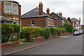
Crouch Road, Burnham on Crouch
Solid looking houses in Burnham's back streets.
Image: © Stephen McKay
Taken: 13 Jun 2015
0.17 miles
4
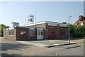
Burnham-on-Crouch fire station
Burnham-on-Crouch fire station, Albert Road, Burnham-on-Crouch, Essex
Image: © Kevin Hale
Taken: 4 Jun 2010
0.21 miles
5

The New Welcome Sailor, Burnham on Crouch
Image: © Robert Eva
Taken: 1 Feb 2018
0.24 miles
