IMAGES TAKEN NEAR TO
Maldon Road, SOUTHMINSTER, CM0 7RR
Introduction
This page details the photographs taken nearby to Maldon Road, CM0 7RR by members of the Geograph project.
The Geograph project started in 2005 with the aim of publishing, organising and preserving representative images for every square kilometre of Great Britain, Ireland and the Isle of Man.

There are currently over 7.5m images from over14,400 individuals and you can help contribute to the project by visiting https://www.geograph.org.uk
Image Map
Images are licensed for reuse under creativecommons.org/licenses/by-sa/2.0
Notes
- Clicking on the map will re-center to the selected point.
- The higher the marker number, the further away the image location is from the centre of the postcode.
Image Listing (2 Images Found)
Images are licensed for reuse under creativecommons.org/licenses/by-sa/2.0
Image
Details
Distance
1
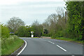
Maldon Road towards Steeple
Many of the roads on the Dengie peninsula follow the ancient grid of the field boundaries, which meant that a diagonal trend across them was a series of right-angled corners. On this road the sharp corners have been replaced with more sweeping bends, probably dating from when access was improved to build Bradwell power station. Here the old road goes straight on to abruptly turn left. It is a pity that they didn't go the whole hog and straighten out the whole road.
Image: © Robin Webster
Taken: 9 May 2021
0.06 miles
2
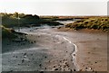
The extreme southern end of Mayland Creek at low tide
Image: © Dennis Troughton
Taken: 1 Aug 2001
0.24 miles