IMAGES TAKEN NEAR TO
Seaway, SOUTHMINSTER, CM0 7ND
Introduction
This page details the photographs taken nearby to Seaway, CM0 7ND by members of the Geograph project.
The Geograph project started in 2005 with the aim of publishing, organising and preserving representative images for every square kilometre of Great Britain, Ireland and the Isle of Man.

There are currently over 7.5m images from over14,400 individuals and you can help contribute to the project by visiting https://www.geograph.org.uk
Image Map
Images are licensed for reuse under creativecommons.org/licenses/by-sa/2.0
Notes
- Clicking on the map will re-center to the selected point.
- The higher the marker number, the further away the image location is from the centre of the postcode.
Image Listing (14 Images Found)
Images are licensed for reuse under creativecommons.org/licenses/by-sa/2.0
Image
Details
Distance
1
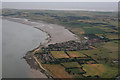
Aerial photo of St Lawrence
This aerial photo covers quite a few grid squares on the Dengie Peninsula, although the prominent focus is of St Lawrence.
Image: © terry joyce
Taken: 6 Jul 2010
0.09 miles
3
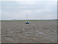
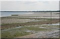
Mudflats at St Lawrence Bay
A lonely boat rests on the mudflats at St Lawrence Bay in the Blackwater estuary. In the far distance is the decommissioned nuclear reactor at Bradwell.
Image: © Roger Jones
Taken: 29 Sep 2013
0.16 miles
4
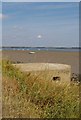
Type 22 and St Lawrence Bay
This is St Lawrence bay looking back along the Blackwater towards Stone. For an explanation of type 22 see http://www.pillboxesuk.co.uk/
Image: © Glyn Baker
Taken: 16 Aug 2006
0.17 miles
6
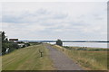
Sea wall path at St Lawrence Bay
A seasonal inland diversion to this section of the path is provided to avoid disturbing the winter visiting birds.
Image: © Trevor Harris
Taken: 21 Jul 2016
0.20 miles
7
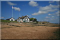
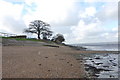
The Stone Inn
The slipway belongs to The Stone Watersports Club
Image: © Paul Franks
Taken: 17 Jun 2017
0.23 miles
8
The end of Main Road, St Lawrence
The River Blackwater is beyond.
Image: © Robin Webster
Taken: 9 May 2021
0.23 miles
9
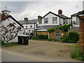
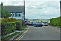
Houses west of the Stone Inn
These back on to Tinnocks Lane, but face the seawall and the Blackwater estuary. The white weather-boarding is typical of older properties in the area.
Image: © Stefan Czapski
Taken: 11 Jun 2016
0.23 miles
10
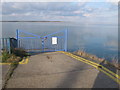
Stone Ramp
Ramp into St Lawrence Bay from Main Road near "The Stone Inn" pub.
Image: © Roger Jones
Taken: 26 Feb 2012
0.23 miles