IMAGES TAKEN NEAR TO
Main Road, SOUTHMINSTER, CM0 7LR
Introduction
This page details the photographs taken nearby to Main Road, CM0 7LR by members of the Geograph project.
The Geograph project started in 2005 with the aim of publishing, organising and preserving representative images for every square kilometre of Great Britain, Ireland and the Isle of Man.

There are currently over 7.5m images from over14,400 individuals and you can help contribute to the project by visiting https://www.geograph.org.uk
Image Map
Images are licensed for reuse under creativecommons.org/licenses/by-sa/2.0
Notes
- Clicking on the map will re-center to the selected point.
- The higher the marker number, the further away the image location is from the centre of the postcode.
Image Listing (6 Images Found)
Images are licensed for reuse under creativecommons.org/licenses/by-sa/2.0
Image
Details
Distance
2
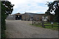
At Mott's Farm
Just off the Main Road that leads to Stone. Mott's is still a working farm, though some of the accommodation now seems to be used for holiday purposes.
Image: © Stefan Czapski
Taken: 11 Jun 2016
0.06 miles
3
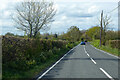
Main Road, St Lawrence
Towards the modern, coastal part of the village.
Image: © Robin Webster
Taken: 9 May 2021
0.07 miles

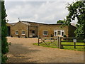
6

Footpath from Motts Farm
Looking back towards the farm
Image: © Glyn Baker
Taken: 3 Nov 2016
0.15 miles