IMAGES TAKEN NEAR TO
Dukes Avenue, SOUTHMINSTER, CM0 7HA
Introduction
This page details the photographs taken nearby to Dukes Avenue, CM0 7HA by members of the Geograph project.
The Geograph project started in 2005 with the aim of publishing, organising and preserving representative images for every square kilometre of Great Britain, Ireland and the Isle of Man.

There are currently over 7.5m images from over14,400 individuals and you can help contribute to the project by visiting https://www.geograph.org.uk
Image Map (Loading...)


Getting Data...Please wait
Leaflet Map data © OpenStreetMap
Images are licensed for reuse under creativecommons.org/licenses/by-sa/2.0
Notes
- Clicking on the map will re-center to the selected point.
- The higher the marker number, the further away the image location is from the centre of the postcode.
Image Listing (20 Images Found)
Images are licensed for reuse under creativecommons.org/licenses/by-sa/2.0
Image
Details
Distance
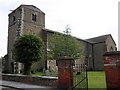
3
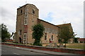
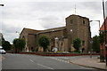
St. Leonard's Church, Southminster, Essex
Clearly a very ancient church, with a uniquely-shaped tower.
Image: © Dr Neil Clifton
Taken: 11 Aug 2006
0.22 miles
4
Essex: St. Leonard's Church, Southminster
Image: © Dr Neil Clifton
Taken: 11 Aug 2006
0.22 miles
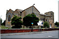
7
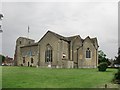
Southminster church from the south-east
Image: © Stefan Czapski
Taken: 11 Jun 2016
0.22 miles
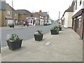
9
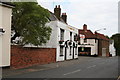
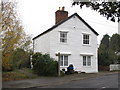
The 'King's Head', Southminster
All of the pubs in Southminster look very attractive. It would be quite easy to lose a day there...
Image: © Dr Neil Clifton
Taken: 11 Aug 2006
0.23 miles
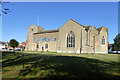
10
Essex: St. Leonard's Church, Southminster
Image: © Dr Neil Clifton
Taken: 11 Aug 2006
0.23 miles