IMAGES TAKEN NEAR TO
Hall Road, SOUTHMINSTER, CM0 7EH
Introduction
This page details the photographs taken nearby to Hall Road, CM0 7EH by members of the Geograph project.
The Geograph project started in 2005 with the aim of publishing, organising and preserving representative images for every square kilometre of Great Britain, Ireland and the Isle of Man.

There are currently over 7.5m images from over14,400 individuals and you can help contribute to the project by visiting https://www.geograph.org.uk
Image Map (Loading...)


Getting Data...Please wait
Leaflet Map data © OpenStreetMap
Images are licensed for reuse under creativecommons.org/licenses/by-sa/2.0
Notes
- Clicking on the map will re-center to the selected point.
- The higher the marker number, the further away the image location is from the centre of the postcode.
Image Listing (37 Images Found)
Images are licensed for reuse under creativecommons.org/licenses/by-sa/2.0
Image
Details
Distance
1
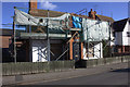
Old school house, Southminster
Still under renovation
Image: © Robert Eva
Taken: 1 Feb 2018
0.01 miles
2
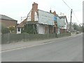
The Old School House, 8 Hall Road, Southminster
Planning permission has been granted by Maldon District Council under application number 10/00386A/FUL for the “renovation of 8 windows, replacement of 2 windows, replacement of upvc guttering and re-render rear wall elevation with lime render”. It is a grade II listed building dating from the 18th century http://www.britishlistedbuildings.co.uk/en-119277-8-hall-road-southminster-essex
Image: © John Baker
Taken: 3 Apr 2014
0.02 miles
3
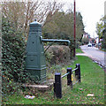
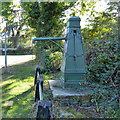
Detail of roadside pump, Southminster
Image: © Robin Webster
Taken: 22 Oct 2016
0.05 miles
4
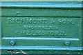
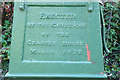
Water Pump
Village pump, with inscriptions: "Erected by The Governors of The Charter House, March 1832" and "Richmond and Son Engineers, Chelmsford"
Of importance as the only known identifiable casting of the Richmond Foundry and one of only 2 obelisk survivors, the other circa 1850 at Ridgewell:Essex and the Industrial Revolution. John Booker, E.R.O. 66. 1974.
Listed building see: http://list.english-heritage.org.uk/resultsingle.aspx?uid=1111795
Image: © Roger Jones
Taken: 6 Nov 2011
0.05 miles
5
Roadside pump, Southminster
For a reverse view of this grade II listed pump, see Image For details of the inscriptions, see Image and Image
Image: © Robin Webster
Taken: 22 Oct 2016
0.05 miles
6
Detail of roadside pump, Southminster
Image: © Robin Webster
Taken: 22 Oct 2016
0.05 miles
8
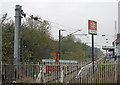
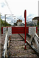
Catenary tensioning weights at the end of the line
A view of the end of the line at Southminster railway station.
The term "catenary" is used for overhead lines which use at least 2 wires, with the contact wire being held in tension almost parallel to the track; this picture gives a clear view of the line tensioning weights on the post closest to the camera.
Southminster station was opened by the Great Eastern Railway in 1889. It is now the terminus of the Crouch Valley Line, trains go to Wickford and occasionally through to London Liverpool Street.
Image: © Roger Jones
Taken: 8 Nov 2011
0.07 miles
9
Next Stop Sellafield!
It is almost certain that Southminster Station and the whole Crouch Valley line would have been Beechingized in the 1960s if it had not been for the requirement for Bradwell nuclear power station’s waste to be shipped by rail to Cumbria. You can see the power station at Image
Image: © Glyn Baker
Taken: 1 May 2006
0.07 miles
10
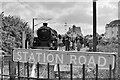
The 'Cockney Coaster' at Southminster, 2002
76079 has headed the train from Wickford, trailing 45407 at the other end.
Image: © Robin Webster
Taken: 6 May 2002
0.07 miles