IMAGES TAKEN NEAR TO
North End, SOUTHMINSTER, CM0 7DN
Introduction
This page details the photographs taken nearby to North End, CM0 7DN by members of the Geograph project.
The Geograph project started in 2005 with the aim of publishing, organising and preserving representative images for every square kilometre of Great Britain, Ireland and the Isle of Man.

There are currently over 7.5m images from over14,400 individuals and you can help contribute to the project by visiting https://www.geograph.org.uk
Image Map
Images are licensed for reuse under creativecommons.org/licenses/by-sa/2.0
Notes
- Clicking on the map will re-center to the selected point.
- The higher the marker number, the further away the image location is from the centre of the postcode.
Image Listing (29 Images Found)
Images are licensed for reuse under creativecommons.org/licenses/by-sa/2.0
Image
Details
Distance
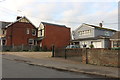
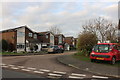
2
Houses, North End, Southminster
Nothing special, apparently - no national listing.
Image: © Robin Webster
Taken: 22 Oct 2016
0.03 miles
3
Older houses, Northend
A group of older houses, most likely C19 or earlier: this part of Southminster has a few older buildings from C17 onwards.
Image: © Roger Jones
Taken: 5 Nov 2011
0.03 miles
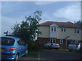
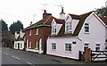
7
Home Farm House, Southminster
A grade II listed building, 15th or 16th century with later alterations and additions.
Image: © Robin Webster
Taken: 22 Oct 2016
0.09 miles
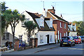
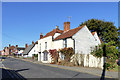
8
An old house in Southminster
This house, which looks like it is early 18th century, is called Home Farm House that indicates there was once a farm here, but now it is surrounded by houses. The road junction is on the B.1021
Image: © Robert Edwards
Taken: 5 Mar 2008
0.09 miles
9
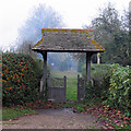
Graveyard Gate
Just beyond this lych gate is a narrow strip of land which may well be the remains of a previously larger cemetery.
Smoke from a nearby bonfire slightly gives the background the appearance of being wrapped in mist: if you look carefully you can see the outline of a dark ghostly figure walking amongst the graves.
Image: © Roger Jones
Taken: 5 Nov 2011
0.11 miles
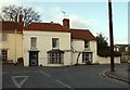
10
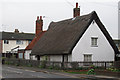
Thatched cottage with weatherboarding
Cottage, C17 or earlier; timber framed and weatherboarded; thatched roof
Listed building see: http://list.english-heritage.org.uk/resultsingle.aspx?uid=1237492 for more info
Image: © Roger Jones
Taken: 5 Nov 2011
0.11 miles