IMAGES TAKEN NEAR TO
Sheepcotes Lane, SOUTHMINSTER, CM0 7AG
Introduction
This page details the photographs taken nearby to Sheepcotes Lane, CM0 7AG by members of the Geograph project.
The Geograph project started in 2005 with the aim of publishing, organising and preserving representative images for every square kilometre of Great Britain, Ireland and the Isle of Man.

There are currently over 7.5m images from over14,400 individuals and you can help contribute to the project by visiting https://www.geograph.org.uk
Image Map
Images are licensed for reuse under creativecommons.org/licenses/by-sa/2.0
Notes
- Clicking on the map will re-center to the selected point.
- The higher the marker number, the further away the image location is from the centre of the postcode.
Image Listing (4 Images Found)
Images are licensed for reuse under creativecommons.org/licenses/by-sa/2.0
Image
Details
Distance
1
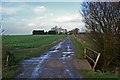
Bridge on Sheepcotes Lane
Sheepcotes Lane runs from Southminster to Foxhall Rd. It is a “route with public access” as far as the Bridge. Beyond that it is a bridle path that runs to the left of Sheepcotes farmhouse.
Image: © Glyn Baker
Taken: 30 Dec 2006
0.17 miles
2
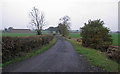
Farm track and footpath
Public footpath on track to Sheepcotes
Image: © Roger Jones
Taken: 5 Nov 2011
0.22 miles
3
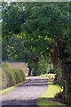
Farm Drive to Sheepcotes
This farm drive is a public bridleway to Southminster.
Image: © Glyn Baker
Taken: 23 Sep 2017
0.23 miles
4
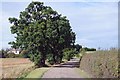
Bridleway to Foxhall Rd
Leaving Sheepcotes farm
Image: © Glyn Baker
Taken: 23 Sep 2017
0.24 miles