IMAGES TAKEN NEAR TO
Maes Pennant Road, HOLYWELL, CH8 9PY
Introduction
This page details the photographs taken nearby to Maes Pennant Road, CH8 9PY by members of the Geograph project.
The Geograph project started in 2005 with the aim of publishing, organising and preserving representative images for every square kilometre of Great Britain, Ireland and the Isle of Man.

There are currently over 7.5m images from over14,400 individuals and you can help contribute to the project by visiting https://www.geograph.org.uk
Image Map
Images are licensed for reuse under creativecommons.org/licenses/by-sa/2.0
Notes
- Clicking on the map will re-center to the selected point.
- The higher the marker number, the further away the image location is from the centre of the postcode.
Image Listing (18 Images Found)
Images are licensed for reuse under creativecommons.org/licenses/by-sa/2.0
Image
Details
Distance
1

Bryn Pennant Primary School, Maes Pennant
Image: © Eirian Evans
Taken: 31 Jan 2009
0.11 miles
2
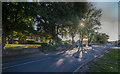
Maes Pennant
Looking up Ffordd Pennant, Bryn Pennant primary school on the left
Image: © Geraint Roberts
Taken: 30 Aug 2016
0.13 miles
3
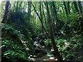
Waterfall Near Maes Pennant
Not the most dramatic of waterfalls, but the level of noise is quite substantial, and on a hot summer afternoon, it was quite refreshing to spend time here, with the tall trees also blotting out most of the sun's rays.
Image: © Mihacel
Taken: 5 Jul 2012
0.19 miles
4
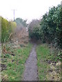
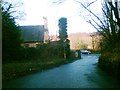
Footpath to Rhewl Mostyn
Footpath and bridleway from the Lletty Hotel to Rhewl Mostyn.
Image: © Eirian Evans
Taken: 31 Jan 2009
0.19 miles
5
Gwaith brics addurniadol / Decorative brickwork
Image: © Ceri Thomas
Taken: 25 Oct 2021
0.20 miles
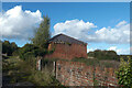
6
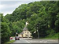
Lletty Hotel, Mostyn
The back of the Lletty Hotel, as viewed from the minor road which leads up towards Maes Pennant from the A548 coastal road.
Image: © Mihacel
Taken: 17 Feb 2007
0.22 miles
7
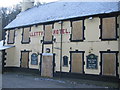
Lletty Hotel, Mostyn
A familiar sight to travellers on the A548 between Chester and Rhyl, the lletty hotel is now closed and boarded up. The unusual sign above the door is still evident.
Image: © Phil Williams
Taken: 29 Dec 2005
0.22 miles
8
Lletty Hotel, Mostyn
Another picture of the Lletty Hotel in Mostyn. Another submission from myself of the same pub a third time. This I feel because the first geograph in this square of the same subject did not permit a full appreciation of the beautiful surroundings in which this disused (shame) public house is situated.
Image: © Mihacel
Taken: 2 Jun 2007
0.22 miles
9
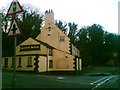
Lletty Hotel, Mostyn
Another view of the disused Letty Hotel in Mostyn. This taken from the A548 coastal road. It is a shame that such a familiar pub to holiday-makers and day-trippers on the way to Rhyl and Prestatyn is not operational. The building at first glance looks so structurally sound, and even has a sky dish on the roof. The sign at the side looks impressive as well. Somebody open it up!
Image: © Mihacel
Taken: 17 Feb 2007
0.22 miles
10
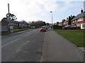
Ffordd Pennant
An established housing estate fronts this road (on the right) and is serviced by a small shopping parade opposite which includes the local Post Office. The local school is just a little further up on the left and the police station is close by.
Image: © Maggie Cox
Taken: 3 Mar 2013
0.23 miles