IMAGES TAKEN NEAR TO
Gwespyr, HOLYWELL, CH8 9LT
Introduction
This page details the photographs taken nearby to CH8 9LT by members of the Geograph project.
The Geograph project started in 2005 with the aim of publishing, organising and preserving representative images for every square kilometre of Great Britain, Ireland and the Isle of Man.

There are currently over 7.5m images from over14,400 individuals and you can help contribute to the project by visiting https://www.geograph.org.uk
Image Map
Images are licensed for reuse under creativecommons.org/licenses/by-sa/2.0
Notes
- Clicking on the map will re-center to the selected point.
- The higher the marker number, the further away the image location is from the centre of the postcode.
Image Listing (7 Images Found)
Images are licensed for reuse under creativecommons.org/licenses/by-sa/2.0
Image
Details
Distance
1
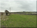
Footpath between Gwespyr and Llanasa Road
Image: © Gary Rogers
Taken: 11 Jan 2015
0.13 miles
2
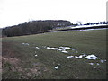
Grazing fields and woodland
From Tanrallt Road looking towards Gelli Bank
Image: © Maggie Cox
Taken: 29 Mar 2013
0.18 miles
3

This was the home of Frank Nicholson...
A Welsh singer who was tragically killed by a stallion on Gwespyr Park in 1928
Image: © Gary Rogers
Taken: 11 Jan 2015
0.21 miles
4
Gwespyr Children's Play Area
Basketball hoop in what was once a small stone quarry
Image: © Gary Rogers
Taken: 11 Jan 2015
0.23 miles
5
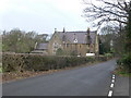
Old Talacre School
This building is on the Llanasa road between Gronant and Llanasa. It was at one time a school run by Catholic nuns for the benefit of local working class children.
Image: © Eirian Evans
Taken: 29 Jan 2008
0.24 miles
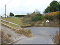
6

Footpath
Steps and kissing gate for the footpath to Gwespyr from the Llanasa road, near the old Talacre School.
Image: © Eirian Evans
Taken: 29 Jan 2008
0.24 miles
7
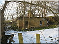
Small ruin
On Llanasa road by the start of the footpath to Gwespyr
Image: © Maggie Cox
Taken: 29 Mar 2013
0.25 miles