IMAGES TAKEN NEAR TO
Tanlan, Ffynnongroyw, HOLYWELL, CH8 9JY
Introduction
This page details the photographs taken nearby to CH8 9JY by members of the Geograph project.
The Geograph project started in 2005 with the aim of publishing, organising and preserving representative images for every square kilometre of Great Britain, Ireland and the Isle of Man.

There are currently over 7.5m images from over14,400 individuals and you can help contribute to the project by visiting https://www.geograph.org.uk
Image Map
Images are licensed for reuse under creativecommons.org/licenses/by-sa/2.0
Notes
- Clicking on the map will re-center to the selected point.
- The higher the marker number, the further away the image location is from the centre of the postcode.
Image Listing (2 Images Found)
Images are licensed for reuse under creativecommons.org/licenses/by-sa/2.0
Image
Details
Distance
1
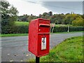
Postbox by the A548
CH8 29. Royal Mail list this box as 'Tan Y Coed'.
Image: © David Bremner
Taken: 7 Nov 2022
0.17 miles
2
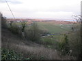
Low lying fields
Taken from hillside scrubland across the A5480. You can see the gas terminal at Talacre on the other side of the Chester to Holyhead railway and in the far distance Liverpool Bay, the Dee estuary and the Wirral
Image: © Maggie Cox
Taken: 29 Mar 2013
0.25 miles