IMAGES TAKEN NEAR TO
Bryn Garth, HOLYWELL, CH8 9HQ
Introduction
This page details the photographs taken nearby to Bryn Garth, CH8 9HQ by members of the Geograph project.
The Geograph project started in 2005 with the aim of publishing, organising and preserving representative images for every square kilometre of Great Britain, Ireland and the Isle of Man.

There are currently over 7.5m images from over14,400 individuals and you can help contribute to the project by visiting https://www.geograph.org.uk
Image Map
Images are licensed for reuse under creativecommons.org/licenses/by-sa/2.0
Notes
- Clicking on the map will re-center to the selected point.
- The higher the marker number, the further away the image location is from the centre of the postcode.
Image Listing (3 Images Found)
Images are licensed for reuse under creativecommons.org/licenses/by-sa/2.0
Image
Details
Distance
1
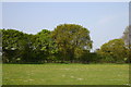
A field and trees
Looking across a field of daisies and dandelions with several trees in the distance.
Image: © R lee
Taken: 7 May 2008
0.14 miles
2
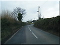
Lane approaching Pen-y-Ffordd village boundary
Image: © Colin Pyle
Taken: 2 Apr 2013
0.22 miles
3
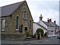
Pen-y-ffordd
Church and cottages in the centre of the village
Image: © Dot Potter
Taken: 26 Feb 2006
0.25 miles