IMAGES TAKEN NEAR TO
Ffordd Pentre, HOLYWELL, CH8 8SL
Introduction
This page details the photographs taken nearby to Ffordd Pentre, CH8 8SL by members of the Geograph project.
The Geograph project started in 2005 with the aim of publishing, organising and preserving representative images for every square kilometre of Great Britain, Ireland and the Isle of Man.

There are currently over 7.5m images from over14,400 individuals and you can help contribute to the project by visiting https://www.geograph.org.uk
Image Map
Images are licensed for reuse under creativecommons.org/licenses/by-sa/2.0
Notes
- Clicking on the map will re-center to the selected point.
- The higher the marker number, the further away the image location is from the centre of the postcode.
Image Listing (6 Images Found)
Images are licensed for reuse under creativecommons.org/licenses/by-sa/2.0
Image
Details
Distance

3
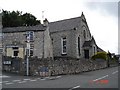
Carmel Capel
Church and stone cottage in the village of Carmel
Image: © Dot Potter
Taken: 5 Aug 2005
0.18 miles
4
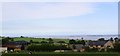
Golch Farm
This picture was taken from the A5026 looking NE at Golch Farm, the Dee estuary can be seen in the distance.
Image: © Dave Smethurst
Taken: 20 Sep 2005
0.19 miles