IMAGES TAKEN NEAR TO
Dyserth Road, HOLYWELL, CH8 8RN
Introduction
This page details the photographs taken nearby to Dyserth Road, CH8 8RN by members of the Geograph project.
The Geograph project started in 2005 with the aim of publishing, organising and preserving representative images for every square kilometre of Great Britain, Ireland and the Isle of Man.

There are currently over 7.5m images from over14,400 individuals and you can help contribute to the project by visiting https://www.geograph.org.uk
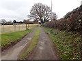
Image Map
Images are licensed for reuse under creativecommons.org/licenses/by-sa/2.0
Notes
- Clicking on the map will re-center to the selected point.
- The higher the marker number, the further away the image location is from the centre of the postcode.
Image Listing (4 Images Found)
Images are licensed for reuse under creativecommons.org/licenses/by-sa/2.0
Image
Details
Distance
1
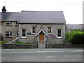
S?on Lloc, Welsh Methodist Chapel
The Chapel was built as a Wesleyan place of worship in 1829 and rebuilt 60 years later. It is famous as the Chapel of the 'Plygain' (Capel y Plygain). The Plygain is a service of music and worship which takes place every year early on Christmas morning.
'Lloc' is the Welsh word for a livestock enclosure.
Image: © Tim Stuart
Taken: 28 Aug 2008
0.11 miles
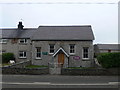
3
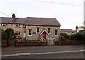
Sion Welsh Methodist Chapel, Lloc
This small stone-built chapel was built in 1810, and then rebuilt/modified in 1829.
Image: © Eirian Evans
Taken: 12 Feb 2019
0.11 miles