IMAGES TAKEN NEAR TO
Celyn Close, HOLYWELL, CH8 8RJ
Introduction
This page details the photographs taken nearby to Celyn Close, CH8 8RJ by members of the Geograph project.
The Geograph project started in 2005 with the aim of publishing, organising and preserving representative images for every square kilometre of Great Britain, Ireland and the Isle of Man.

There are currently over 7.5m images from over14,400 individuals and you can help contribute to the project by visiting https://www.geograph.org.uk
Image Map
Images are licensed for reuse under creativecommons.org/licenses/by-sa/2.0
Notes
- Clicking on the map will re-center to the selected point.
- The higher the marker number, the further away the image location is from the centre of the postcode.
Image Listing (5 Images Found)
Images are licensed for reuse under creativecommons.org/licenses/by-sa/2.0
Image
Details
Distance
1
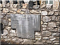
Milestone, Carmel near Holywell
Sign to what Wikipedia calls a Friary, now a Franciscan "retreat" ( https://en.wikipedia.org/wiki/Pantasaph#Friary ). In 1899 it was shown as St David's Monastery on maps. Adjacent to the road sign "Mwdwl Eithin / Carmel Hill".
Other view Image
Inscription: Pantasaph / Monastery / ☚ / Half a Mile
Milestone Society ID: FLT_PAS00
Image: © James Kelly
Taken: 17 Jun 2021
0.05 miles

4

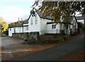
A5026 looking to the Dee estuary and Liverpool beyond
Image: © Colin Pyle
Taken: 2 Apr 2013
0.16 miles
