IMAGES TAKEN NEAR TO
Babell Road, HOLYWELL, CH8 8RB
Introduction
This page details the photographs taken nearby to Babell Road, CH8 8RB by members of the Geograph project.
The Geograph project started in 2005 with the aim of publishing, organising and preserving representative images for every square kilometre of Great Britain, Ireland and the Isle of Man.

There are currently over 7.5m images from over14,400 individuals and you can help contribute to the project by visiting https://www.geograph.org.uk
Image Map
Images are licensed for reuse under creativecommons.org/licenses/by-sa/2.0
Notes
- Clicking on the map will re-center to the selected point.
- The higher the marker number, the further away the image location is from the centre of the postcode.
Image Listing (7 Images Found)
Images are licensed for reuse under creativecommons.org/licenses/by-sa/2.0
Image
Details
Distance
1
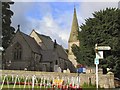
St.Pauls Church Gorsedd
This church is at the main village crossroads, and faces the Druid's Inn.
Image: © Roger May
Taken: 25 Aug 2005
0.10 miles
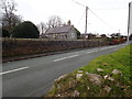
4
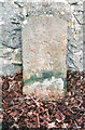
Old Milestone by Babell Road, Gorsedd, Whitford parish
Milestone by the UC road (was A5151), Babell Road in parish of Whitford (Flintshire District), at Gorsedd crossroads, junction with Carmel Road, against churchyard wall, West side of road.
Surveyed
Milestone Society National ID: FLT_STHO08
Image: © Milestone Society
Taken: Unknown
0.11 miles
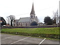
5
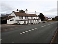
The Druid Inn, Gorsedd
At the centre of the village, opposite St Paul's church
Image: © Eirian Evans
Taken: 12 Feb 2019
0.13 miles
6
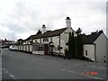
Druids Inn Gorsedd
The Druids Inn public house in the village of Gorsedd on the
Image: © Dot Potter
Taken: 5 Aug 2005
0.17 miles