IMAGES TAKEN NEAR TO
Brynford, HOLYWELL, CH8 8LS
Introduction
This page details the photographs taken nearby to CH8 8LS by members of the Geograph project.
The Geograph project started in 2005 with the aim of publishing, organising and preserving representative images for every square kilometre of Great Britain, Ireland and the Isle of Man.

There are currently over 7.5m images from over14,400 individuals and you can help contribute to the project by visiting https://www.geograph.org.uk
Image Map
Images are licensed for reuse under creativecommons.org/licenses/by-sa/2.0
Notes
- Clicking on the map will re-center to the selected point.
- The higher the marker number, the further away the image location is from the centre of the postcode.
Image Listing (6 Images Found)
Images are licensed for reuse under creativecommons.org/licenses/by-sa/2.0
Image
Details
Distance
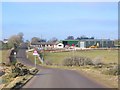
1
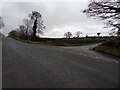
Lixwm turn
Ffordd Berthen junction with Halkyn Mountain road.
Image: © J Scott
Taken: 13 Jan 2011
0.10 miles
2
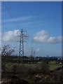
Under power
Pant-y-groes beneath electricity pylons, Halkyn Mountain.
Image: © J Scott
Taken: 16 Feb 2011
0.11 miles
4
Pant cudd
Pant Y Croes, alongside Halkyn Mountain road and beyond electricity pylon.
Image: © J Scott
Taken: 13 Jan 2011
0.20 miles
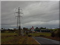
5
Pant Y Groes
Farm adjacent to the road over Pentre Halkyn, having just passed the quarry entrances. View to the west.
Image: © Roger May
Taken: 30 Jan 2006
0.21 miles
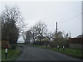
6
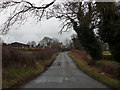
Ffordd Berthen
Ffordd Berthen leading to Lixwm from Halkyn Mountain.
Image: © J Scott
Taken: 13 Jan 2011
0.22 miles