IMAGES TAKEN NEAR TO
Uwch Y Mor, HOLYWELL, CH8 8HF
Introduction
This page details the photographs taken nearby to Uwch Y Mor, CH8 8HF by members of the Geograph project.
The Geograph project started in 2005 with the aim of publishing, organising and preserving representative images for every square kilometre of Great Britain, Ireland and the Isle of Man.

There are currently over 7.5m images from over14,400 individuals and you can help contribute to the project by visiting https://www.geograph.org.uk
Image Map
Images are licensed for reuse under creativecommons.org/licenses/by-sa/2.0
Notes
- Clicking on the map will re-center to the selected point.
- The higher the marker number, the further away the image location is from the centre of the postcode.
Image Listing (4 Images Found)
Images are licensed for reuse under creativecommons.org/licenses/by-sa/2.0
Image
Details
Distance
2
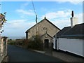
Salem, Pentre Halkyn
Built in 1841 as a Wesleyan chapel.
Image: © Eirian Evans
Taken: 5 Dec 2007
0.20 miles
3
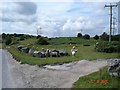
Common land at Pentre Halkyn
Common land above the village next to the quarry. Sheep graze freely on the roadsides
Image: © Dot Potter
Taken: 5 Aug 2005
0.23 miles
4
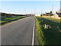
Minor road near Halkyn Mountain
Looking north-westward.
Image: © Peter Wood
Taken: 18 Nov 2018
0.25 miles