IMAGES TAKEN NEAR TO
Pentre Road, HOLYWELL, CH8 8BS
Introduction
This page details the photographs taken nearby to Pentre Road, CH8 8BS by members of the Geograph project.
The Geograph project started in 2005 with the aim of publishing, organising and preserving representative images for every square kilometre of Great Britain, Ireland and the Isle of Man.

There are currently over 7.5m images from over14,400 individuals and you can help contribute to the project by visiting https://www.geograph.org.uk
Image Map
Images are licensed for reuse under creativecommons.org/licenses/by-sa/2.0
Notes
- Clicking on the map will re-center to the selected point.
- The higher the marker number, the further away the image location is from the centre of the postcode.
Image Listing (6 Images Found)
Images are licensed for reuse under creativecommons.org/licenses/by-sa/2.0
Image
Details
Distance
2
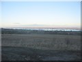
Cropland at Pentre Halkyn
A view looking east-southeast over cropland at Pentre Halkyn. The observant may just spot Beeston Castle and the Peckforton Hills in the far distance at right, with Connahs Quay power station and the Flintshire Bridge in the sunshine at centre.
Image: © Phil Williams
Taken: 1 Jan 2006
0.04 miles
3
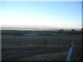
Dee Estuary from Pentre Halkyn
A view looking north over farmland at Pentre Halkyn. The A55 North Wales expressway can be seen at the end of the cropland, with the Dee Estuary and the Wirral beyond. The observant may be able to spot St. John's Tower on the Liverpool skyline in the far distance at centre.
Image: © Phil Williams
Taken: 1 Jan 2006
0.04 miles
4
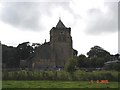
Halkyn Church
The parish church at Halkyn (Helygain)
Image: © Dot Potter
Taken: 5 Aug 2005
0.16 miles
5
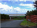
Down The Lines
View down Llys-y-Nant across the River Dee estuary to the Wirral.
Image: © J Scott
Taken: 9 Jun 2010
0.23 miles
6
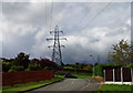
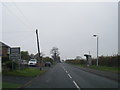
Uphill View
View uphill Llys-y-Nant to electricity pylon.
Image: © J Scott
Taken: 9 Jun 2010
0.24 miles