IMAGES TAKEN NEAR TO
Plas Yr Ywen, HOLYWELL, CH8 7UF
Introduction
This page details the photographs taken nearby to Plas Yr Ywen, CH8 7UF by members of the Geograph project.
The Geograph project started in 2005 with the aim of publishing, organising and preserving representative images for every square kilometre of Great Britain, Ireland and the Isle of Man.

There are currently over 7.5m images from over14,400 individuals and you can help contribute to the project by visiting https://www.geograph.org.uk
Image Map
Images are licensed for reuse under creativecommons.org/licenses/by-sa/2.0
Notes
- Clicking on the map will re-center to the selected point.
- The higher the marker number, the further away the image location is from the centre of the postcode.
Image Listing (47 Images Found)
Images are licensed for reuse under creativecommons.org/licenses/by-sa/2.0
Image
Details
Distance
1
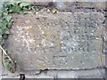
Inscribed stone in wall on Halkyn Street, Holywell
it's hard to make out what is inscribed on the stone but inscription possibly recorded at https://archwilio.org.uk/arch/query/page.php?watprn=CPAT89961&dbname=cpat&tbname=core&sessid=CHI1un884ff&queryid=Q379416001570991613
See also: Image
Image: © Meirion
Taken: 5 Sep 2019
0.03 miles
2
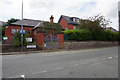
Ysgol Y Fron County Primary School
Halkyn Street, Holywell.
Image: © Ian S
Taken: 24 Jul 2019
0.06 miles
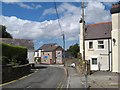
3

Brynford Street 2
Another view of Brynford Street, Holywell.
Image: © Jonathan Wilkins
Taken: 8 Aug 2018
0.08 miles
4
Brynford Street 1
A view along Brynford Street, Holywell.
Image: © Jonathan Wilkins
Taken: 8 Aug 2018
0.10 miles
5
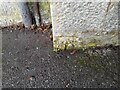
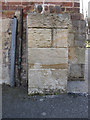
Ordnance Survey Cut Mark
This OS cut mark can be found on the NW buttress of the school. It marks a point 372.23ft above mean sea level.
Image: © Adrian Dust
Taken: 28 Mar 2023
0.10 miles
6
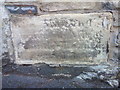
Bench mark on the former British School
This bench mark is at the very bottom of the north-west buttress on the former British School (Boys, Girls & Infants) as shown on the 1871 Town Plan. The mark is indicated on all maps up to 1963, but is no longer included on the modern O.S. database.
Image: © John S Turner
Taken: 8 Feb 2011
0.10 miles
7
Inscribed stone (2) in wall on Halkyn Street, Holywell
A very worn inscribed stone on Halkyn Street in Holywell. See also: Image
Image: © Meirion
Taken: 5 Sep 2019
0.11 miles
8
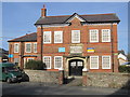
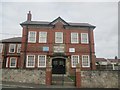
Territorial Drill Hall, Halkyn Street, Holywell
The stone plaque above the main door ensures there is no mistaking that this was built as the Territorial Drill Hall in 1914. It stands in Halkyn Street, not far from the centre of Holywell, opposite an old school, Ysgol y Fron.
Image: © John S Turner
Taken: 8 Feb 2011
0.11 miles
9
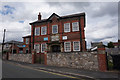
Territorial Drill Hall
Dated 1914, on Halkyn Street.
Image: © Ian S
Taken: 24 Jul 2019
0.11 miles
10
Territorial drill hall on Halkyn Street, Holywell
TERRITORIAL
A 1914 D
DRILL HALL
For a closer view of the inscription see: Image
Image: © Meirion
Taken: 5 Sep 2019
0.11 miles