IMAGES TAKEN NEAR TO
Meadow Villas, Greenfield Road, HOLYWELL, CH8 7QJ
Introduction
This page details the photographs taken nearby to Meadow Villas, Greenfield Road, CH8 7QJ by members of the Geograph project.
The Geograph project started in 2005 with the aim of publishing, organising and preserving representative images for every square kilometre of Great Britain, Ireland and the Isle of Man.

There are currently over 7.5m images from over14,400 individuals and you can help contribute to the project by visiting https://www.geograph.org.uk
Image Map
Images are licensed for reuse under creativecommons.org/licenses/by-sa/2.0
Notes
- Clicking on the map will re-center to the selected point.
- The higher the marker number, the further away the image location is from the centre of the postcode.
Image Listing (60 Images Found)
Images are licensed for reuse under creativecommons.org/licenses/by-sa/2.0
Image
Details
Distance
1
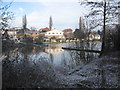
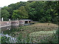
Flour Mill pond
A view looking north over the southern section of the Flour Mill pond in the Greenfield Valley Heritage Park. See http://www.greenfieldvalley.com for more information.
Image: © Phil Williams
Taken: 29 Dec 2005
0.02 miles
2
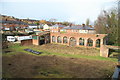
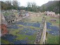
Greenfield Valley Heritage Park - Meadow Mill
This is a former copper rolling mill dating back to 1787 and used for supplying copper plate for sheathing ships' bottoms, among other uses. It was powered by a water wheel and the remains of a leat can be seen between two buttresses on the dam that is supporting the photographer. There is also a picturesque overflow weir. This is one of several ruins preserved along the valley and is well worth a visit.
Image: © Chris Allen
Taken: 8 Feb 2014
0.03 miles
3
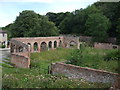
Meadow Mill on the Greenfield Heritage trail (1)
At one time this was a lead rolling mill.
Image: © Richard Hoare
Taken: 17 Aug 2011
0.04 miles
4
Meadow Mill on the Greenfield Heritage trail (2)
At one time this was a lead rolling mill.
Image: © Richard Hoare
Taken: 17 Aug 2011
0.04 miles
5
Industrial ruins below Battery Pool in the Greenfield Valley
The ruins here and elsewhere nearby are extensive. This little sloping valley was industrialised in the 1700's with a densely packed concentration of entrepreneurial industries by the 1770's that included manufacturing batteries, shaping copper pots and pans for shipment worldwide, rolling mills, flour mills, cotton mills and wire mills making copper and brass wire. Every remaining brick here could be said to represent a life; a child worker, a cotton worker, the recipients of an industrial accident, a life cut short by long hours labouring for a pittance - or conversely an opportunist who through hard work and the courage of their convictions may have made the world a slightly better place, for themselves and others near and far, however briefly.
Image: © Jeremy Bolwell
Taken: 5 Feb 2012
0.05 miles
6
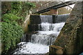
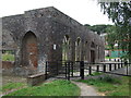
Greenfield Valley Heritage Park - mill pond overflow
This is the overflow weir from the pond that supplied Meadow Mill's water wheel. The bridge leads you on to the massive dam.
Image: © Chris Allen
Taken: 8 Feb 2014
0.05 miles
7
Mill pond at Bryn Celyn
Part of the Greenfield Valley Heritage trail. Here it crosses the weir.
Image: © Richard Hoare
Taken: 17 Aug 2011
0.05 miles
8
A boundary sign on the Greenfield Valley Heritage Trail
I am obliged to fellow geographer John Turner who after 5 years was able to enlighten me as to the significance of this sign.
Dated 1934, this post defines the boundary of land once owned by the Grosvenor Chater company, in the Greenfield Valley Heritage Park. Grosvenor Chater were a London paper making company who acquired the nearby Abbey Mill in 1854. The mill closed in 1982 and the company was dissolved in 1992. There is more information about the company https://archiveshub.jisc.ac.uk/search/archives/dab28981-19ef-31db-890f-d3beb0bc7223?component=6fcd729f-3920-35f9-8b17-56227289a0fe
Image: © Richard Hoare
Taken: 17 Aug 2011
0.06 miles
9
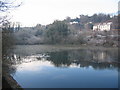
Mill Pond, Bryn Celyn
Looking southwest across one of the mill ponds in the Greenfield Valley Heritage Park, towards Bryn Celyn.
Image: © Phil Williams
Taken: 29 Dec 2005
0.08 miles
10
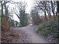
Greenfield Heritage Park
Looking northeast along the trackbed of the Holywell branch railway line. This is now a footpath through the Greenfield Valley Heritage Park. When I was a youngster, there was a footbridge at this location, carrying the pedestrian path from the slope at left over the railway and down to the path at right.
Image: © Phil Williams
Taken: 29 Dec 2005
0.08 miles