IMAGES TAKEN NEAR TO
Hillside Court, HOLYWELL, CH8 7PJ
Introduction
This page details the photographs taken nearby to Hillside Court, CH8 7PJ by members of the Geograph project.
The Geograph project started in 2005 with the aim of publishing, organising and preserving representative images for every square kilometre of Great Britain, Ireland and the Isle of Man.

There are currently over 7.5m images from over14,400 individuals and you can help contribute to the project by visiting https://www.geograph.org.uk
Image Map
Images are licensed for reuse under creativecommons.org/licenses/by-sa/2.0
Notes
- Clicking on the map will re-center to the selected point.
- The higher the marker number, the further away the image location is from the centre of the postcode.
Image Listing (102 Images Found)
Images are licensed for reuse under creativecommons.org/licenses/by-sa/2.0
Image
Details
Distance
1
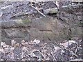
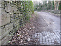
Bench mark alongside the old railway line to Holywell Town - 2
This bench mark is at the very end of a section of wall alongside the former railway line to Holywell. I can only find it indicated on the 1963 O.S. map, and it is not recorded on the modern O.S. database. See also Image]
Image: © John S Turner
Taken: 8 Feb 2011
0.06 miles
2
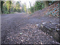
The track bed of the former Holywell Town railway - 2
Looking north along the old trackbed of the railway between Holywell Junction and Holywell Town. The track is now a popular walking route linking Greenfield Heritage Park with Holywell. On the right there is a bench mark very close to the ground - Image
Image: © John S Turner
Taken: 8 Feb 2011
0.06 miles
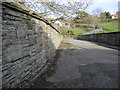
4
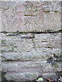
Bench mark alongside the old railway line to Holywell Town - 1
This bench mark is on the stone wall along the east side of the former railway line to Holywell Town. The mark is first indicated on the 1963 O.S. map and again in 1990, but it is not recorded on the modern O.S. database. The track bed is now a popular walking route that links Holywell with the Greenfield Valley Heritage Park http://www.greenfieldvalley.com/ See also Image
Image: © John S Turner
Taken: 8 Feb 2011
0.07 miles
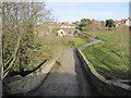
5
The track bed of the former Holywell Town railway - 1
Looking along the track bed of the disused railway that is now a popular walking route between Holywell and the Greenfield Valley Heritage Park http://www.greenfieldvalley.com/ There is a bench mark on the wall on the left - Image
Image: © John S Turner
Taken: 8 Feb 2011
0.07 miles
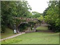
6
Bridge over the former Holywell Town station, and a bench mark
This substantial stone bridge now carries only pedestrian traffic across the valley and site of Holywell Town station. There is a bench mark on the ston on the left - Image
Image: © John S Turner
Taken: 8 Feb 2011
0.09 miles
7
Bridge over the former Holywell Town station
Holywell Town station has long since been closed but this substantial stone bridge still provides pedestrian access from Tescos car park across to the Strand housing estate.
Image: © John S Turner
Taken: 8 Feb 2011
0.09 miles
8
Former Road Bridge, Holywell
Original crossing a railway line, which is now part of the heritage park.
Image: © Chris Andrews
Taken: 17 Aug 2018
0.09 miles
9
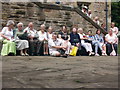
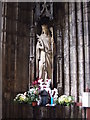
Pilgrims gather at the Well
A day pilgrimage gathers for prayer
Image: © Ian Cardinal
Taken: 5 Jun 2010
0.09 miles
10
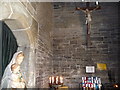
The Catholic chapel building, St. Winefride's Well, Holywell
The interior walls are covered in graffiti in the form of people's names.
Image: © Jeremy Bolwell
Taken: 20 Jun 2010
0.10 miles