IMAGES TAKEN NEAR TO
CH8 7LX
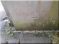
Introduction
This page details the photographs taken nearby to CH8 7LX by members of the Geograph project.
The Geograph project started in 2005 with the aim of publishing, organising and preserving representative images for every square kilometre of Great Britain, Ireland and the Isle of Man.

There are currently over 7.5m images from over14,400 individuals and you can help contribute to the project by visiting https://www.geograph.org.uk
Image Map
Images are licensed for reuse under creativecommons.org/licenses/by-sa/2.0
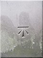
Notes
- Clicking on the map will re-center to the selected point.
- The higher the marker number, the further away the image location is from the centre of the postcode.
Image Listing (78 Images Found)
Images are licensed for reuse under creativecommons.org/licenses/by-sa/2.0
Image
Details
Distance
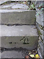
1
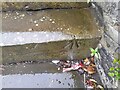
Ordnance Survey Rivet
This OS rivet can be found on the step of No12 Coleshill Street. It marks a point 113.020m above mean sea level.
Image: © Adrian Dust
Taken: 28 Mar 2023
0.03 miles
2
Rivet benchmark at 12 Coleshill Street, Holywell
For more details see: https://www.bench-marks.org.uk/bm36831
Image: © Meirion
Taken: 5 Sep 2019
0.03 miles
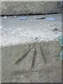
3
The front of #12 Coleshill Street, Holywell
There is a rivet bench mark on one of the steps up to #12 Coleshill Street - Image The building next door is the Tabernacle, United Reformed Church.
Image: © John S Turner
Taken: 8 Feb 2011
0.03 miles
4
Rivet bench mark on step at #12 Coleshill Street
This rivet bench mark is on the step up to the front garden of #12 Coleshill Street. It is indicated on all maps from the 1871 Town Plan onwards. See also Image
Image: © John S Turner
Taken: 8 Feb 2011
0.03 miles
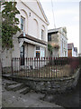
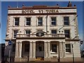
5
Hotel Victoria, Holywell
Although its address is Coleshill Street, Hotel Victoria stands in a prime position facing north west along High Street, and it looks splendid in the low winter sun. It is a Grade II listed building and following a five-year period of closure it was refurbished and re-opened in 2010.
It was named the King's Arms Hotel on the 1871 Town Plan, and once had a 1GL bench mark on a guardstone on the left-hand/north-west corner of the building. The guardstone would have been essential in the days before pavements, but with the advent of pavements, first shown on the 1963 O.S. map, the stone would have been an inconvenience to pedestrians. The bench mark disappeared from the same 1963 map, no doubt along with the removal of the stone.
Image: © John S Turner
Taken: 8 Feb 2011
0.05 miles
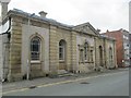
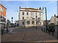
7
The front of the old Court House in Halkyn Street
Looking along the front of the old Court House in Halkyn Street. There is a bench mark on the corner facing the camera - Image
Image: © John S Turner
Taken: 8 Feb 2011
0.05 miles
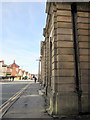
8
Ordnance Survey Cut Mark
This OS cut mark can be found on the old Court House, Halkyn Street. It marks a point 112.872m above mean sea level.
Image: © Adrian Dust
Taken: 28 Mar 2023
0.05 miles
9
Benchmark on courthouse, Holywell
For more details see: https://www.bench-marks.org.uk/bm36826
Image: © Meirion
Taken: 5 Sep 2019
0.05 miles