IMAGES TAKEN NEAR TO
School Lane, HOLYWELL, CH8 7HR
Introduction
This page details the photographs taken nearby to School Lane, CH8 7HR by members of the Geograph project.
The Geograph project started in 2005 with the aim of publishing, organising and preserving representative images for every square kilometre of Great Britain, Ireland and the Isle of Man.

There are currently over 7.5m images from over14,400 individuals and you can help contribute to the project by visiting https://www.geograph.org.uk
Image Map
Images are licensed for reuse under creativecommons.org/licenses/by-sa/2.0
Notes
- Clicking on the map will re-center to the selected point.
- The higher the marker number, the further away the image location is from the centre of the postcode.
Image Listing (110 Images Found)
Images are licensed for reuse under creativecommons.org/licenses/by-sa/2.0
Image
Details
Distance
1
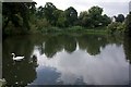
Pond by Greenfield Valley Heritage Centre
Image: © Paul Buckingham
Taken: 25 Aug 2012
0.11 miles
2
Gear wheel and shaft by Greenfield Valley car park
This large gear wheel and shaft is placed at the entrance to one of the car parks for the Greenfield Valley Heritage Park http://www.greenfieldvalley.com/ The buildings behind are on Greenfield Road.
Image: © John S Turner
Taken: 8 Feb 2011
0.11 miles
3
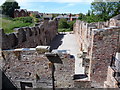
Lower Mill, Greenfield Valley Heritage Park
A series of old mills and associated industrial buildings have had their ruins preserved as part of the site. This is just one of several. Others include the Abbey Wire Mill, Victoria Mill and Meadow Mill.
Image: © Jeremy Bolwell
Taken: 20 Jun 2010
0.12 miles
4
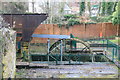
Greenfield Valley Heritage Park - Abbey Mill
Former water powered wire mill. The water wheel is modern and generates a small amount of 'green' electricity for use on site. You can see from the size of the rusty old launder that the pit once contained a much larger wheel. The configuration clearly shows the wheel to be overshot.
Image: © Chris Allen
Taken: 8 Feb 2014
0.12 miles
5
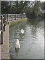
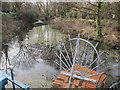
Parys Mill dam in Greenfield Valley Heritage Park
This dam holds back the waters of the lower pond in the Greenfield valley. The swan in the foreground is obviously camera shy.
Image: © John S Turner
Taken: 8 Feb 2011
0.12 miles
6
The Holywell Stream
The stream emerges at St Winifred's Well in Holywell, and here it was used to drive the millwheel for a wire works.
Image: © Eirian Evans
Taken: 26 Jan 2008
0.12 miles
7
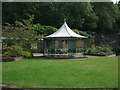
Bandstand Greenfield Valley Heritage trail
A rather splendid bandstand, unfortunately the entrance was padlocked so closer examination was not possible.
Image: © Richard Hoare
Taken: 17 Aug 2011
0.13 miles
8
Bandstand and park within Greenfield Valley Heritage Park
Locked out of season but looking great for an open air venue for the spring and summer.
Image: © Jeremy Bolwell
Taken: 5 Feb 2012
0.13 miles
9
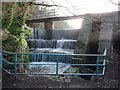
The Holywell Stream, Greenfield Valley
The Holywell Stream rises at St Winifred's Well and once powered all the industrial mills in the Greenfield Valley. On the right the stream flows over a man-made horseshoe fall Image
Image: © John S Turner
Taken: 8 Feb 2011
0.13 miles
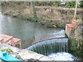
10
Spillway in the Greenfield Valley Heritage Park
The water cascades catch the winter sunshine nicely.
Image: © Jeremy Bolwell
Taken: 5 Feb 2012
0.13 miles