IMAGES TAKEN NEAR TO
Moor Lane, HOLYWELL, CH8 7DN
Introduction
This page details the photographs taken nearby to Moor Lane, CH8 7DN by members of the Geograph project.
The Geograph project started in 2005 with the aim of publishing, organising and preserving representative images for every square kilometre of Great Britain, Ireland and the Isle of Man.

There are currently over 7.5m images from over14,400 individuals and you can help contribute to the project by visiting https://www.geograph.org.uk
Image Map
Images are licensed for reuse under creativecommons.org/licenses/by-sa/2.0
Notes
- Clicking on the map will re-center to the selected point.
- The higher the marker number, the further away the image location is from the centre of the postcode.
Image Listing (6 Images Found)
Images are licensed for reuse under creativecommons.org/licenses/by-sa/2.0
Image
Details
Distance
1
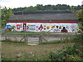
Community Centre artwork
A view looking south towards the artwork on the community centre on the Holway estate. The grass area in the foreground is a remnant of a mineral tramway and now forms part of a public footpath to St. Winefrides Well.
Image: © Phil Williams
Taken: 11 Aug 2006
0.05 miles
2
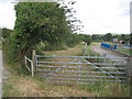
Footpath to St. Winefrides Well
A view looking to the southeast along the line of an old mineral tramway, which now forms a public footpath from the Holway to St. Winefrides Well, via Level Lane. When I was a youth, this was one large field, the community centre to the right not having been built. At left is the track up to Moor Farm, and a public footpath to Maes Glas (Greenfield).
Image: © Phil Williams
Taken: 11 Aug 2006
0.05 miles
3
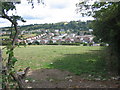
The Holway estate
A view looking south from a field entrance on the track to Moor Farm, showing the Holway estate and Pen-y-Ball hill behind.
Image: © Phil Williams
Taken: 11 Aug 2006
0.13 miles
5
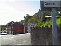
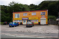
Pit Stop
Service Station on the A5026 at the turning for Carmel.
Image: © Roger May
Taken: 25 Aug 2005
0.15 miles
6
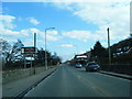
Ffordd Holway at Holywell village boundary
Image: © Colin Pyle
Taken: 2 Apr 2013
0.17 miles