IMAGES TAKEN NEAR TO
Erw Goed, MOLD, CH7 6YE
Introduction
This page details the photographs taken nearby to Erw Goed, CH7 6YE by members of the Geograph project.
The Geograph project started in 2005 with the aim of publishing, organising and preserving representative images for every square kilometre of Great Britain, Ireland and the Isle of Man.

There are currently over 7.5m images from over14,400 individuals and you can help contribute to the project by visiting https://www.geograph.org.uk
Image Map
Images are licensed for reuse under creativecommons.org/licenses/by-sa/2.0
Notes
- Clicking on the map will re-center to the selected point.
- The higher the marker number, the further away the image location is from the centre of the postcode.
Image Listing (7 Images Found)
Images are licensed for reuse under creativecommons.org/licenses/by-sa/2.0
Image
Details
Distance
1
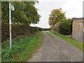
Farm track and public footpath in Bryn-y-baal
This public footpath links Chambers Lane to the A494.
Image: © John S Turner
Taken: 11 Oct 2018
0.15 miles
2
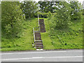
Steps off the A494
The footpath crosses the A494 near Mynydd Isa, via two sets of steps. This is looking from the northern side towards the other embankment.
Image: © David Dixon
Taken: 23 May 2011
0.19 miles
5
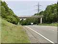
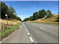
Bridge Over The A494
Bridge carrying Bryn-y-Baal Road over the A494, just to the west of Mynydd Isa.
Image: © David Dixon
Taken: 23 May 2011
0.21 miles
6
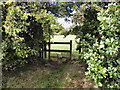
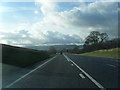
Stile off A494
This stile gives access to Image] from the steps at the side of the A494.
Image: © David Dixon
Taken: 23 May 2011
0.21 miles
7
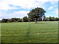
Path to Argoed Farm
The path runs across the middle of this field, just off the A494
Image: © David Dixon
Taken: 23 May 2011
0.24 miles