IMAGES TAKEN NEAR TO
Bod Offa Lane, MOLD, CH7 6RE
Introduction
This page details the photographs taken nearby to Bod Offa Lane, CH7 6RE by members of the Geograph project.
The Geograph project started in 2005 with the aim of publishing, organising and preserving representative images for every square kilometre of Great Britain, Ireland and the Isle of Man.

There are currently over 7.5m images from over14,400 individuals and you can help contribute to the project by visiting https://www.geograph.org.uk
Image Map
Images are licensed for reuse under creativecommons.org/licenses/by-sa/2.0
Notes
- Clicking on the map will re-center to the selected point.
- The higher the marker number, the further away the image location is from the centre of the postcode.
Image Listing (3 Images Found)
Images are licensed for reuse under creativecommons.org/licenses/by-sa/2.0
Image
Details
Distance
1
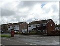
Houses, Buckley
Showing position of Postbox No. CH7 107.
Image: © JThomas
Taken: 19 Apr 2024
0.13 miles
2
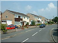
Downtown Buckley
On the '40s map, this area is all fields. This is Pant-y-fawnog.
Image: © David Medcalf
Taken: 3 Jul 2006
0.19 miles
3
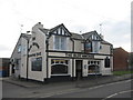
The Blue Anchor
The Blue Anchor public house on Mold Road.
Image: © Sue Adair
Taken: 21 Feb 2009
0.23 miles