IMAGES TAKEN NEAR TO
Pantyffrith, Berthddu, MOLD, CH7 6PX
Introduction
This page details the photographs taken nearby to Pantyffrith, Berthddu, CH7 6PX by members of the Geograph project.
The Geograph project started in 2005 with the aim of publishing, organising and preserving representative images for every square kilometre of Great Britain, Ireland and the Isle of Man.

There are currently over 7.5m images from over14,400 individuals and you can help contribute to the project by visiting https://www.geograph.org.uk
Image Map
Images are licensed for reuse under creativecommons.org/licenses/by-sa/2.0
Notes
- Clicking on the map will re-center to the selected point.
- The higher the marker number, the further away the image location is from the centre of the postcode.
Image Listing (4 Images Found)
Images are licensed for reuse under creativecommons.org/licenses/by-sa/2.0
Image
Details
Distance
1
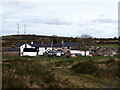
Pant-y-Ffrith, Berth Ddu
Developed from miners cottages.
Image: © Chris Andrews
Taken: 19 Feb 2023
0.01 miles
2
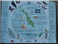
Halkyn Mountain Common
Detail of the plaque on Halkyn Mountain Common.
Image: © Phil Williams
Taken: 1 Jan 2006
0.06 miles
3
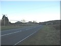
Berth-Ddu
A view looking southeast along the B5123 from Halkyn Mountain Common towards Berth-Ddu. The rising ground in the left distance is Moel Gaer, thought by some to be the true site of King Arthurs Camelot.
Image: © Phil Williams
Taken: 1 Jan 2006
0.06 miles
4
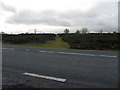
Common route
Footpath leading across Halkyn Common from the B5123.
Image: © J Scott
Taken: 11 Jan 2011
0.25 miles